- Route
- Liknes – Vesterdalen – Kvinlog – Knaben – Tonstad – Dorgefoss – Tjørhom and Kvæven – Suleskard – Suleskarvegen – Brokke on the Rv 9 (Fv 465, Fv 4198, Fv 42, Fv 468 and Fv 450)
- Length
- about 215 km from Liknes to the Rv 9 at Brokke, including the drive up to Knaben and back to Kvinlog (around 60 km). From Flekkefjord it is about 24 km to Liknes.
- Driving time
- Around 4 hours without stops
- Recommended number of days
- 2–3
- Best season
- June–September. Suleskarvegen is closed from 1 November to 20 May, and the mining museum at Knaben and the tourist information in Sirdal are only open in summer.
- Difficulty
- Moderate. No ferries, and every road on the route is open to vehicles up to 19.5 metres long. But over the mountains Suleskarvegen is only 4.5–5 metres wide for long stretches, with gradients of up to 9–10 per cent.
- Last checked
- October 2026
Why this route?
Most people see the south of Norway from the coast. This route heads straight inland: from Liknes, almost at sea level just above Fedafjorden, up the valleys of the Kvina and the Sira and over a plateau that climbs above 1,000 metres, to Setesdal. On the way lie the mining village of Knaben, where molybdenum from the mountain went into steel in two world wars, and Sirdal, a long valley of mountain villages and cabin areas reaching right up to the bare fell.
This is hydropower country. Much of the water in the Kvina and the Sira ends up in Norway's largest power station, at Tonstad. The last stretch is Suleskarvegen, 42 kilometres over high mountain country that is home to Europe's southernmost herd of wild reindeer. The road is closed from 1 November to 20 May, and it is narrow, but it is the reason to drive this route.
The route ends on the Rv 9 in the middle of Setesdal. From there Setesdal and Hovden takes over, north towards Hovden or south towards Kristiansand.
Stops along the route
1. Liknes — the village on the Kvina
Liknes is the centre of Kvinesdal and lies on the river Kvina, just above Fedafjorden. Salmon fishing on the Kvina goes back a long way: from the 1870s until 1913 British anglers leased the fishing rights, and the salmon run some 16 kilometres up the river. Many people from here emigrated to the USA, a flow that lasted from the late 19th century into the 1970s, and Kvinesdal has long held an annual emigrants' festival.
Motorhome tip: By Kvinabadet, the swimming baths, between the baths and Kvinaparken down by the river, the municipality has motorhome spaces with electric hook-ups and a waste disposal point, according to Lister Reiseliv. The toilets at the baths are open from 10:00 to 22:00, and inside you can shower for a fee. Empty your tanks and fill up with fuel here: Liknes has several filling stations, and waste disposal points will be few and far between later on. If you are coming from Flekkefjord, the shortest way into Liknes is the Fv 465, through three tunnels signed at 4.2–4.3 metres.
2. Vesterdalen and Kvinlog — up along the Kvina
The Fv 465 follows the Kvina north through Vesterdalen. About five kilometres from Liknes you pass Rafoss, where the river drops 42 metres. The farm of the same name belonged to Stig Bagge in the 16th century. After 26 kilometres you reach Kvinlog, where the Fv 465 meets the Fv 42. Later you will turn west here towards Sirdal, but first the route carries on north to Knaben.
Motorhome tip: From Liknes to Kvinlog the Fv 465 is mostly more than six metres wide. North of Kvinlog it gets narrower, mostly 5–6 metres. Just north of Liknes the road goes through the Likstein tunnel, only 31 metres long and with no signed height. Statens vegvesen has measured around 4.3–4.4 metres at the edges. Just north of Kvinlog there is a short but steep hill of more than 11 per cent. Map data shows a filling station in Kvinlog, which you pass twice.
3. Knaben — the mining village on the moor
Around 16 kilometres north of Kvinlog the Fv 4198 turns off towards Knaben, and for the last 14 kilometres the road climbs to the mining village, around 600 metres above sea level. Mines were worked here from 1885 to 1973. Molybdenum makes steel harder, and steel for weapons needed it, so Knaben was busy during both world wars. When war came in 1939, no other molybdenum mine in Europe was in operation, and in 1943 the mines were bombed twice by Allied aircraft. Mining ended in 1973, and on 1 May that year the company and its workforce packed up. Underground they had blasted out 21 levels.
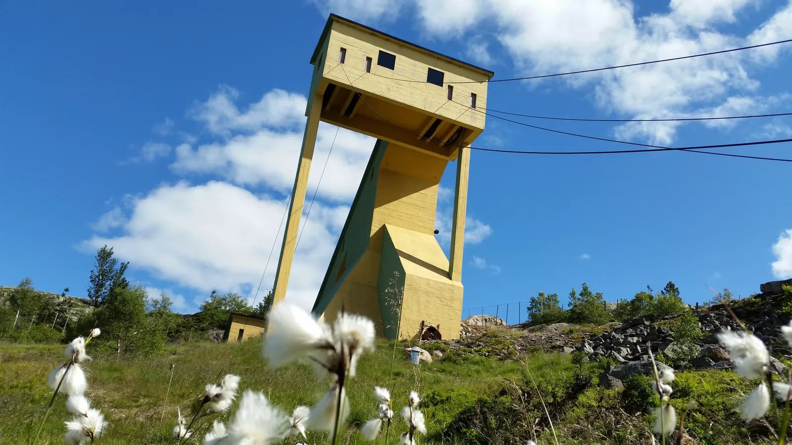
The hoist house, the headframe and the ore washery are still standing, high above the valley, and the houses of the mining village are now homes and holiday houses.
Don't miss: The mining museum in the old administration building, where the first floor is furnished as the director's residence. It is usually open from late June to late August, 11:00–16:00: at weekends, and Friday to Sunday in July and the first half of August. On Sundays over the same period there is a guided tour of the old mine at 13:00, meeting at the hoist house. It is around 7 degrees inside the mountain all year, so bring warm clothes.
Motorhome tip: Stay on the Fv 4198 all the way from the Fv 465. Your satnav may suggest carrying on along the Fv 465 to Risnes and crossing the river there, but Risnes bridge is signed at 3.7 metres high and is only about 2.4 metres wide between its trusses. The Fv 4198 is mostly around 5.5 metres wide, with some stretches under five metres, and several hills of 8–10 per cent. Knaben Camping is in the middle of the village, behind the general store, with 36 spaces for caravans and motorhomes, all with electricity, and a service building with showers, toilets and a washing machine. It is open all year. You choose your own space and collect the invoice from a letterbox in the small hut on the site. The campsite does not mention a waste disposal point. From Knaben you drive back the same way to Kvinlog.
4. Along Sirdalsvatnet to Tonstad
From Kvinlog the Fv 42 heads west, first on a long climb, then down to Sirdalsvatnet and north along the lake. After 37 kilometres you reach Tonstad, the administrative centre of Sirdal, at the head of Sirdalsvatnet. This is where Tonstad power station stands, run by Sira-Kvina kraftselskap since 1968. Measured by annual output it is Norway's largest power station. Its water comes from both the Sira and the Kvina: the upper part of the Kvina is diverted through a 7.6-kilometre tunnel to Tonstad.
Motorhome tip: Just west of Kvinlog the Fv 42 climbs at around 8 per cent for more than two kilometres. Along the lake the road goes through two tunnels of more than 1.3 kilometres each. The Gåseheller tunnel is signed at 4.7 metres, the lowest signed height on the route as described. Fill up in Tonstad, where map data shows two filling stations: after Tonstad they are far apart.
5. Dorgefoss — up Sirdalen
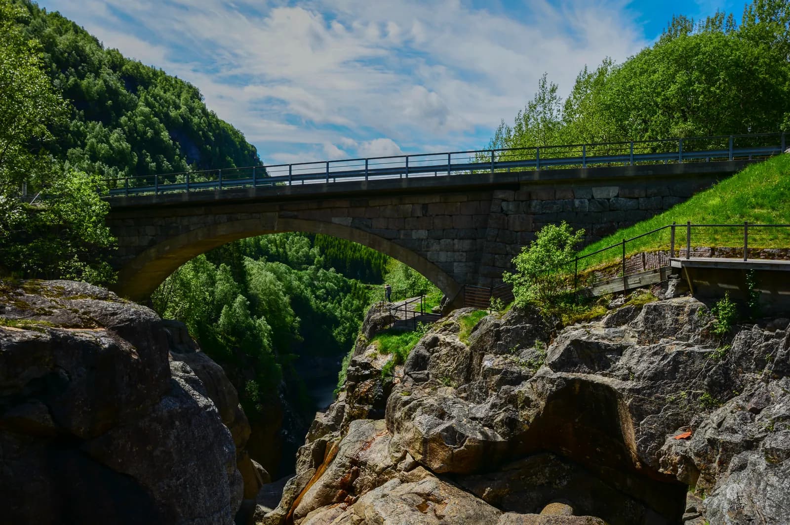
The Fv 468 runs north from Tonstad through Sirdalen, along the river Sira, climbing towards the mountain villages. At Dorgefoss, around 25 kilometres from Tonstad, the river has carved a narrow gorge into the rock. Dorga bridge, a single-arch stone bridge, spans the gorge, and there is a rest area right next to it.
Don't miss: The gorge at Dorgefoss. Park at the rest area and walk over to the bridge.
Motorhome tip: The rest area at Dorgefoss is paved, has one space for large vehicles and is kept open in winter. Just before it the Fv 468 climbs at 8–9 per cent for almost a kilometre. There are two small campsites along the way. Lindeland Camping, around 12 kilometres north of Tonstad, has spaces for caravans and cars from May to August, with showers and a kitchen. Sirdal Huskyfarm at Runtleneset, around 20 kilometres from Tonstad, has six spaces for caravans and motorhomes, without electricity, from May to October. Toilets and showers are a couple of hundred metres away, and the spaces can be booked online.
6. Tjørhom, Sinnes and Kvæven — the mountain villages
Just north of Tjørhom the Fv 468 ends, and the Fv 450 takes you on north past Sinnes and Kvæven. Many of Sirdal's cabin areas lie between Tjørhom and Ådneram, so there can be plenty of traffic here, in summer too. Kvæven is where the sheep are gathered: every autumn they are driven down from their summer grazing in the mountains, and the round-up is a big event in the valley.
Don't miss: Sirdal fjellmuseum, the mountain museum at Kvæven, with old buildings from the valley, the oldest from the 1770s. The information building houses the tourist information, with a café. It is usually open every day from mid-June to early September, 10:00–17:00.
Motorhome tip: Haugen Hytteutleie og Camping lies across the bridge from the Fv 450, between Sinnes and Kvæven, and is the only one of the four campsites at Haugen that takes motorhomes without a booking, all year round. Electricity and the sanitary facilities are included in the price, and the site has a waste disposal point. In winter fewer spaces have electricity, so book ahead then. Sageneset Feriesenter at Tjørhom also has room for motorhomes and caravans, but does not say at what time of year. Call before you come. The Fv 450 between Tjørhom and Suleskard is a good road, mostly more than six metres wide.
7. Suleskard and Ådneram — the top of Sirdal
At the head of the valley lies Ådneram, the highest permanently inhabited settlement in Sirdal, and next to it Suleskard, where the roads divide. From Suleskard, Lysevegen runs west and down the steep hairpins to Lysebotn, around 34 kilometres away. It is described in Ryfylke and Lysefjorden, and the path to Kjerag starts at Øygardsstølen on the way. If you want to include Lysebotn, it is a day trip of its own, there and back.
Motorhome tip: Suleskard Fjellsenter has Fjellbutikken, a grocery shop that also sells firewood and gas. This is the place to stock up before the mountain. The centre rents out cabins. Its own website does not mention motorhome spaces, but according to Lister Reiseliv it has pitches for caravans, so call and ask. Around three kilometres east of the junction is the Suleskard rest area, a small one without a hard surface. It is closed in winter, like the road beyond.
8. Suleskarvegen — over the plateau
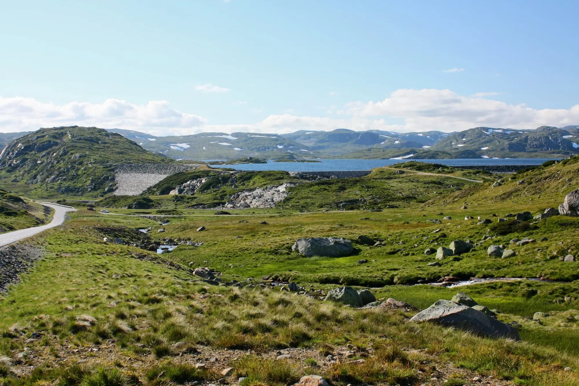
In Sirdal it is called Suleskardveien, in Valle Suleskarvegen: 42 kilometres from Suleskard to the Rv 9 at Brokke. The road opened on 21 September 1990, 16 years after the company set up to build it was founded, and at its highest point you are just over 1,050 metres above sea level. The landscape is open, with low knolls, bog and boulders, glinting lakes and dams. The road passes through the Setesdal Vesthei–Ryfylkeheiane protected landscape area, protected in 2000 partly to safeguard the habitat of Europe's southernmost herd of wild reindeer. For the reindeer's sake, the road must be closed from 1 November up to and including 20 May. It usually opens around midday on 21 May and closes on 31 October.
Around 15 kilometres after Suleskard you pass the dams at Rosskreppfjorden. Sira-Kvina has a power station here, and a large tunnel beneath the road carries water to it.
Don't miss: The Håheller rest area by the main dam. From here you look out over Rosskreppfjorden, and there is drinking water.
Motorhome tip: Much of the road is only 4.5–5 metres wide, about 3.4 metres at its narrowest. Drive slowly, look well ahead and use the wider sections when you meet other traffic. East of Suleskard the road climbs at around 9 per cent for almost a kilometre and at 9.5 per cent for almost two. Håheller is built for coaches, has three spaces for large vehicles and is closed in winter. Throughout the protected area driving off the road is forbidden, and the protection regulations count placing caravans and motorhomes as an intervention in the landscape. The rest areas along the road are for a break. Plan your night in Sirdal or in Setesdal.
9. Brokke — down to Setesdal
After the high mountains the road drops steeply towards Setesdal. Down through Brokke it falls at around 9.5 per cent for more than two and a half kilometres, and then it meets the Rv 9 at Nomeland. Rysstad, with the main building of Setesdalsmuseet, is 3.5 kilometres to the south, and Valle 13 kilometres to the north. Both are described in Setesdal and Hovden.
Motorhome tip: Use a low gear on the hills down through Brokke and let the engine do the braking. The nearest filling station is in Rysstad, and Helle Camping is just south of the village. Valle Camping has the municipality's disposal facility for grey water and toilet waste. Kristiansand is around 140 km away on the Rv 9. South of Bygland the Rv 9 goes through the Fånefjell tunnel, signed at 4.2 metres.
Practical info for motorhomes
Roads: The Fv 465 up to the Fv 4198, the Fv 4198, Fv 42, Fv 468 and Fv 450 are open to vehicles up to 19.5 metres long all the way (Statens vegvesen's road database). The only obstacle is Risnes bridge on the Fv 465, which you do not need to cross: it is signed at 3.7 metres high and is about 2.4 metres wide between its trusses. The Fv 42, Fv 468 and the Fv 450 up to Suleskard are mostly more than six metres wide. The Fv 465 north of Kvinlog and the Fv 4198 up to Knaben are narrower, mostly 5–6 metres. Suleskarvegen is only 4.5–5 metres wide for long stretches, narrower in places, and has gradients of 9–10 per cent. The lowest signed height on the route as described is 4.7 metres, in the Gåseheller tunnel on the Fv 42. The Likstein tunnel just north of Liknes is not signed, but has been measured at around 4.3 metres at the edges. Suleskarvegen is closed from 1 November to 20 May. Check the status of «Fv. 450 Brokke–Suleskard» on vegvesen.no/trafikk or yr.no before you set off, especially early and late in the season. There are no toll stations on the route, but the E39 from Kristiansand and the Rv 9 into Kristiansand do have them.
Parking: In Liknes motorhomes have their own spaces by Kvinabadet. The rest areas at Dorgefoss and Håheller have room for large vehicles, Håheller only in summer. The rest area at Suleskard is small. Never park in passing places, and never off the road.
Overnight stays: Norway's outdoor recreation rules for camping on uncultivated land — at least 150 metres from an inhabited house or cabin, no more than two nights without the landowner's consent — are a good rule of thumb. With a motorhome you only stop where parking is allowed. Over the mountains the road runs through a protected landscape area, where driving off the road is forbidden and the protection regulations count placing caravans and motorhomes as an intervention. Sleep at the motorhome parking in Liknes, at Knaben, or at the campsites in Sirdal or in Setesdal.
Campsites:
- Motorhome parking at Kvinabadet, Liknes — municipal, with electricity and a waste disposal point
- Knaben Camping, Knaben — 36 spaces with electricity, open all year
- Lindeland Camping, north of Tonstad — caravans and cars, May–August
- Sirdal Huskyfarm, Runtleneset — six spaces without electricity, May–October, can be booked online
- Sageneset Feriesenter, Tjørhom — call about the season
- Suleskard Fjellsenter, Suleskard — cabins, ask about a space for a motorhome
- Haugen Hytteutleie og Camping, between Sinnes and Kvæven — no booking needed all year (book in winter), electricity and a waste disposal point
- Helle Camping and Valle Camping, Setesdal — see Setesdal and Hovden
Fuel: Fill up in Liknes and again in Tonstad, where map data shows two filling stations. Knaben has none. After Tonstad, map data shows a station at Tjørhom, and Lister Reiseliv says Suleskard Fjellsenter has petrol and diesel by Fjellbutikken, but we have not been able to confirm either with the owner. There is none over Suleskarvegen, and the next station is in Rysstad, around 60 km from Tjørhom.
Waste disposal: The motorhome parking at Kvinabadet in Liknes has a waste disposal point, and so does Haugen Hytteutleie og Camping in Sirdal. We have not found any at Knaben or over the mountain. In Setesdal Valle Camping has the municipality's disposal facility, and Helle Camping has disposal for its guests.
Ferries: None.
Combine with
- Setesdal and Hovden — this route ends on the Rv 9 between Rysstad and Valle. Drive north towards Hovden or south towards Kristiansand.
- Ryfylke and Lysefjorden — from Suleskard it is around 34 km on Lysevegen down to Lysebotn. Lysevegen is also closed in winter, and the ferry from Lysebotn must be booked.
- Lindesnes and Lista and the North Sea Road through Dalane — both end in Flekkefjord, around 24 km from Liknes.
- Telemarkskanalen and Vest-Telemark — the Fv 450 continues from Rotemo, around 20 km north of Nomeland on the Rv 9, over the mountains to Dalen.
Weather
Sirdal gets a lot of rain. At Sinnes February is the coldest month, with an average of around −4 degrees, and July the warmest at around 13. January is the wettest month and May the driest. On Suleskarvegen you are more than 1,000 metres above sea level, and it can be cold, foggy and windy there even in midsummer. Check yr.no for Tonstad, Sinnes, Suleskard and Brokke.
This route is part of Bobilvei's hand-picked motorhome routes in Norway. Every route is quality-checked with a focus on motorhome suitability, parking and local experiences.