- Route
- Bergen – Gjermundshamn – Årsnes – Rosendal – Furebergsfossen – Sunndal (Bondhusdalen) – Jondalstunnelen – Jondal – Tørvikbygd – Kvamskogen – Bergen (E16, Fv 48, Fv 500 and Fv 49; a loop with two ferries)
- Length
- about 260 km from Bergen and back. The side trip to Uskedalen adds around 28 km there and back, and a run through Folgefonntunnelen to Odda and back around 32 km.
- Driving time
- Around 5 hours without stops, plus two ferry crossings of 20 minutes
- Recommended number of days
- 2–3
- Best season
- May–September. The castle at the Barony is shown on guided tours in summer, and the garden is open all year.
- Difficulty
- Easy. Two-lane road almost all the way and no length limit below 19.5 metres. A single-lane, signal-controlled tunnel at Fureberg and a tight approach to Bondhus call for a little patience.
- Last checked
- October 2026
Why this route?
Kvinnherad is only a couple of hours from Bergen, but it feels further away. On the south side of the Hardangerfjord the mountains rise steeply out of the sea, Folgefonna lies across the summits, and in Rosendal a small 17th-century castle has stood in its garden for more than 350 years.
This is a weekend trip with two ferries. Out across the fjord to Rosendal, in along Maurangerfjorden to the blue-green glacier lake in Bondhusdalen, and home through the mountain to Jondal and over Kvamskogen. The legs are short. You have time for the castle, the walk in to the glacier lake and an evening by the water — and you drive little of the road twice.
Stops along the route
1. Gjermundshamn — the ferry across the fjord
From Bergen, follow the E16 to Trengereid and the Fv 49 to Samnanger. There the Fv 48 takes over, heading south past Eikelandsosen and Mundheim down to the ferry quay — about 100 km from the city centre. The ferry over to Årsnes takes 20 minutes, a little over half an hour when it calls at Varaldsøy. The island has a nature reserve with the largest yew tree in Northern Europe.
Motorhome tip: Fill up before the ferry. Circle K has an unmanned pump open around the clock, with diesel, a couple of hundred metres from the quay, and there is no fuel station in Mauranger. From Os you can shorten the drive with the Hatvik–Venjaneset ferry, but that means two ferries on the way out.
2. Rosendal — boatbuilders and a church from 1255
Above the village stand Malmangersnuten and, a little further in, Melderskin. By the quay you will find Folgefonnsenteret, with the tourist information office, an exhibition on the national park and a small collection on the village's boatbuilding. The Gjøa was built here in 1872 — the sloop in which Roald Amundsen sailed through the Northwest Passage a little over thirty years later. Kvinnherad kyrkje was completed in 1255, and few medieval parish churches in Norway are as tall. From 1678 to 1910 it was the estate owner's private church.
Don't miss: Steinparken — sculptures carved from different kinds of rock, and exhibitions on the history of the Earth. There is no entrance fee, and it is open day and night, all year round. If you have strong legs: Melderskin (1,426 m above sea level), around four hours up from the centre.
Motorhome tip: Rosendal Bubilparkering at Skålafjæro lies by the water in the middle of the village, with 80 pitches all year round, water, emptying, showers and toilets. From here you can walk everywhere: the church is 700 metres away, the Barony a kilometre and a half.
3. The Barony Rosendal — the castle from 1665
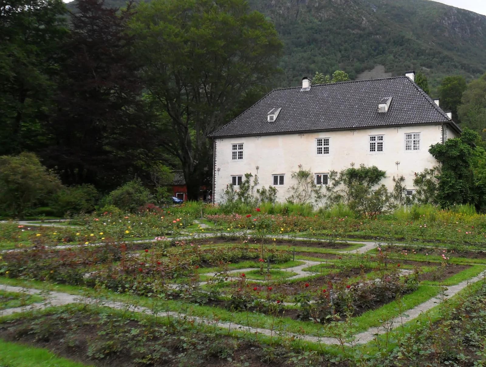
Norway has had one barony, and this was it. The estate became a barony in 1678, thirteen years after the main building at Hatteberg was finished. It was built by Ludvig Rosenkrantz, a Danish nobleman, and Karen Mowat, heiress to one of the country's largest fortunes — the farm was their wedding gift when they married in 1658. In 1927 the estate was given to the University of Oslo, and little inside has changed since.
You enter the castle with a guide. Tours are in Norwegian and English, with around half an hour between them in high season. The garden is open all year. The Renaissance garden was laid out from 1662, the landscape park around it came in the middle of the 19th century, and a small stone tower stands by the pond.
Don't miss: The rose beds in front of the main building, and Hattebergsfossen close by. After landslides in October 2026 the path past the waterfall was closed on its steepest stretch — check kvinnherad.kommune.no before you go.
Motorhome tip: The Barony lists no motorhome parking of its own — walk from the motorhome site, around 20 minutes along Baronivegen. If you are going to a concert there in July or August, buy your ticket in advance.
4. Furebergsfossen — the waterfall under the road
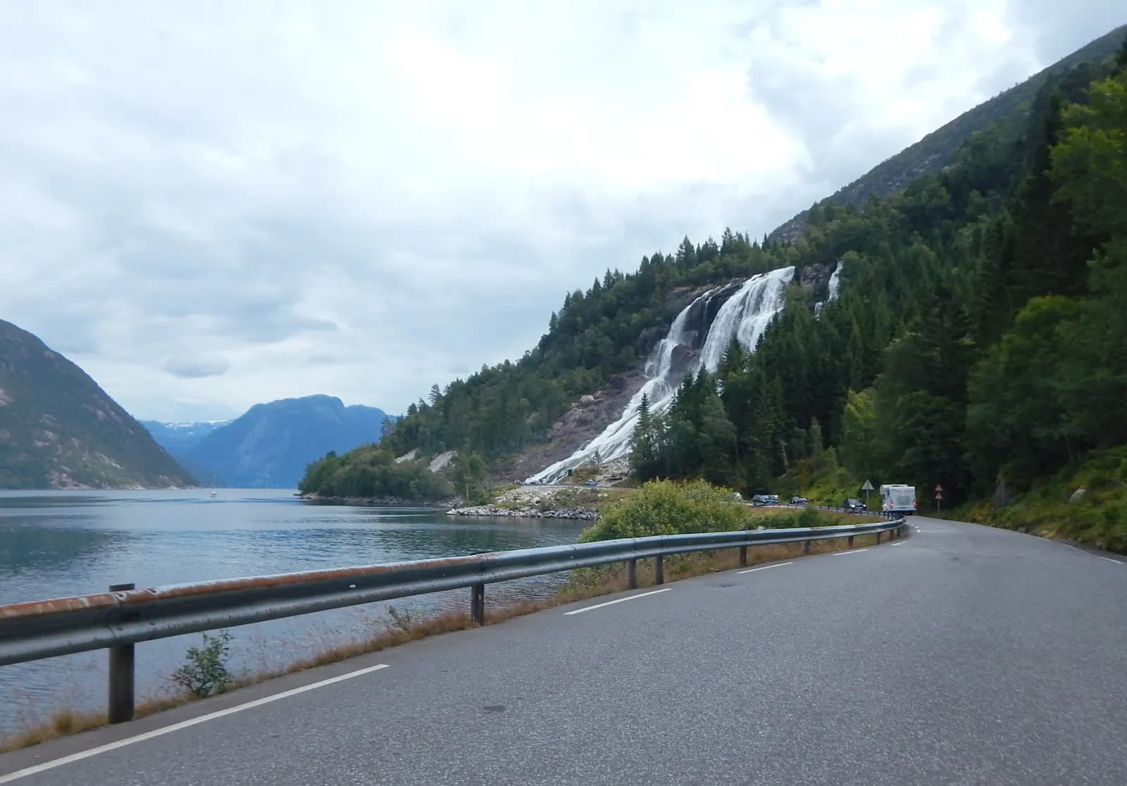
The Fv 500 runs north from Rosendal and then east along the fjord, past Ænes, where the stone church dates from the 13th century. Just after Furebergtunnelen the road crosses Furebergsfossen on a bridge from 2020. The river comes steeply down the hillside and has only a short way left to Maurangerfjorden as it passes beneath you. The waterfall has a free fall of around 20 metres, and from the lay-by it is only a few dozen metres away.
Motorhome tip: Furebergtunnelen (736 metres) has only one lane and traffic lights at both ends — wait for green. The signed height is 4.4 metres. The lay-by at the waterfall is small. If it is full, drive the seven kilometres to Sunndal and come back later, for example on an evening when you are staying at Sundal Camping. Never stop on the road or in a passing place.
5. Bondhusdalen — the ice road to Bondhusvatnet
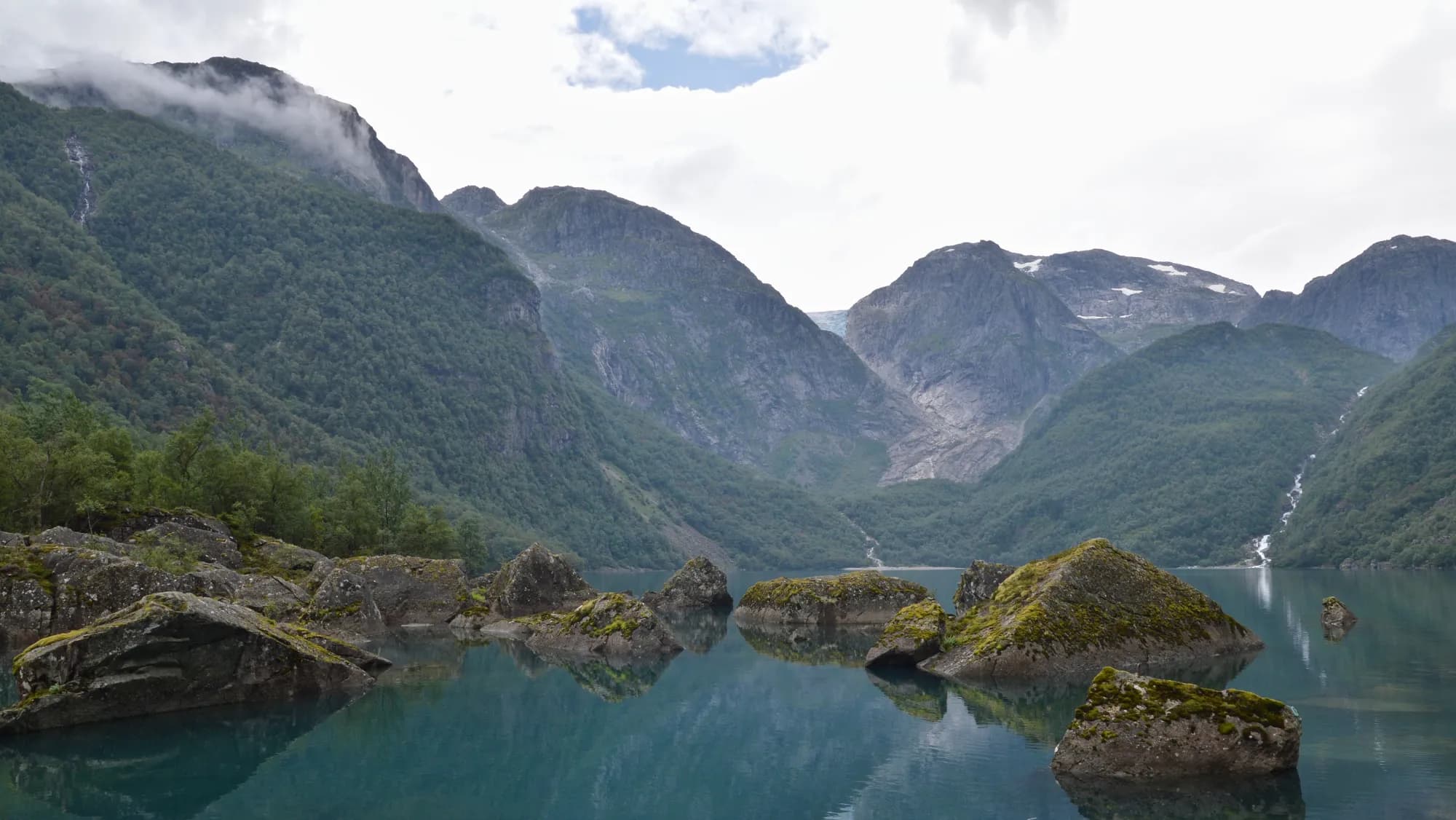
In Sunndal, turn off towards «Bondhusbrea», and after half a kilometre you reach the car park. From there a gentle gravel road runs 2.3 km in to Bondhusvatnet, blue-green beneath steep rock walls. The road was built in the 19th century to haul ice from the glacier down to the sea, and the ice was sold abroad. The round trip is around 4.6 km with just over 130 metres of climbing, and it is fine with a pushchair.
Bondhusbrea, an arm of Folgefonna, has retreated around a kilometre since 1900 and now lies high up in the gorge at the head of the valley. In summer 2026 the police closed the area between the glacier and the lake for a few weeks, because an ice-dammed lake could empty without warning. The ban was lifted in July, and the municipality reported that the lake is still being monitored. Follow the signs.
Don't miss: The picnic tables by the lake. Bring a packed lunch.
Motorhome tip: The road in is narrow and the turning area small — coaches have to stop 300 metres before the car park. With a long motorhome it is easiest to stay at Sundal Camping and walk the extra kilometre. Parking is charged per calendar day; follow the signs. Bondhusvatnet is a drinking-water source: no swimming, and do not pitch a tent closer than 50 metres to the lake.
6. Austrepollen — the fork beneath Folgefonna
At the head of Maurangerfjorden the road divides. To the east, Folgefonntunnelen runs just over 11 km, partly beneath Folgefonna, to Eitrheim near Odda. Before it opened in 2001, the trip round to Odda took several hours — now it takes about a quarter of an hour. To the north, the Fv 49 leads to Jondal. Mauranger power station has its outlet in Austrepollen, and its water arrives through tunnels from, among other places, an intake beneath Bondhusbrea.
Motorhome tip: Folgefonntunnelen is 6 metres wide, has a signed height of 4.5 metres and no toll. From the Odda side it climbs about 3% for the first five kilometres, as calculated in the road database. It suits a side trip, or as the onward road towards Hardanger.
7. Jondalstunnelen and Jondal — back across the fjord
The Fv 49 follows Nordrepollen north and enters Jondalstunnelen, around ten kilometres through the mountain to Jondal on the Hardangerfjord. The tunnel opened in 2012. Above the village, the Folgefonna summer ski centre operated from 1989 to 2024 — the glacier has now melted so much that it has closed. The ferry to Tørvikbygd runs about once an hour and takes 20 minutes.
Motorhome tip: The road along Nordrepollen is exposed to rockfall and has been closed several times in recent years, for anything from a few hours to a couple of days. Check vegvesen.no. If it is closed, drive back via Rosendal and Gjermundshamn. Nordrepollentunnelen has a signed height of 4.2 metres.
8. Kvamskogen — the last leg home
From Tørvikbygd it is 13 km to Norheimsund, where Steinsdalsfossen lies right by the Fv 49. Then the road climbs towards Kvamskogen, with gradients of 7–8% in several places, and on down to Samnanger and Trengereid. From the ferry to Bergen it is just under 90 km.
Motorhome tip: The old tunnels on the climb to Kvamskogen have the lowest signed height of the whole loop, 4.0 metres. The Kvam toll station is on this stretch.
Practical info for motorhomes
Roads: The whole loop is open to combinations of 19.5 metres (load class Bk10 on the Fv 48, Fv 49 and Fv 500 in Statens vegvesen's road database). The roads mostly have 6–7 metres of asphalt. The narrowest stretch is the Fv 500 between Årsnes and Fureberg. The lowest signed height is 4.0 metres, in the tunnels over Kvamskogen. Two tunnels on the Fv 49 and a bridge on Skålagato in the centre of Rosendal are signed at 4.1 metres.
Parking: The car parks at the waterfalls and in Bondhusdalen are small. Never park in a passing place. In Rosendal, the motorhome site at Skålafjæro is the best place to stop.
Overnight stays: Use the motorhome site and the campsites. On uncultivated land (utmark) the Outdoor Recreation Act requires that you cause no damage or nuisance, that tents stand at least 150 metres from an inhabited house or cabin, and that you stay no more than two nights in the same place without permission from the owner or user. Your motorhome must be on a lawful parking place — never out in the terrain. Bondhusdalen is a protected landscape area, and motor traffic is banned there.
Campsites:
- Rosendal Bubilparkering, Skålafjæro — 80 pitches by the water, open all year
- Rosendal Hyttetun — on the Fv 500 three kilometres north of the centre, no advance booking, call early on the day
- Rabben Feriesenter, Uskedalen — 14 km south-west of Rosendal, with a beach and a waste disposal point
- Sundal Camping, Sunndal in Mauranger — a kilometre from the Bondhus car park, room for 50–60 motorhomes, no advance booking
Fuel: An unmanned pump open around the clock by the ferry quay in Gjermundshamn. South-west of Rosendal there are stations in Dimmelsvik and Uskedalen, and more at Husnes. There are none in Mauranger. On the way home: Norheimsund.
Waste disposal: Rosendal Bubilparkering (toilet and grey water) and Rabben Feriesenter in Uskedalen. Not in the toilets at the car parks.
Tolls: The Bergen toll ring and the Kvam toll station. The rate depends on weight, fuel type and whether you have a tag — see ferde.no.
Ferries:
- Gjermundshamn–Årsnes (Fjord1 for Skyss) — 20 minutes, around 35 when the ferry calls at Varaldsøy. One or two departures an hour from early morning to late evening.
- Jondal–Tørvikbygd (Fjord1 for Skyss) — 20 minutes, about one departure an hour.
- From Os: Hatvik–Venjaneset, around 12 minutes. From Stord and Haugesund: Skjersholmane–Ranavik, around 40 minutes.
Timetables at skyss.no. The fare depends on the length of your motorhome, including anything carried on it, and an AutoPASS tag gives a discount. Arrive in good time in July.
Combine with
- Hardanger — from Tørvikbygd it is 13 km to Norheimsund, where that loop begins. Or drive through Folgefonntunnelen from Austrepollen to Odda, around 16 km, and join it there.
- Across Hardangervidda — from Norheimsund it is around 75 km along the fjord and over the Hardanger Bridge to Eidfjord, where that route ends. Drive it in reverse towards Geilo.
- Haugesund and Karmøy — south from Rosendal past Husnes to the Ranavik–Skjersholmane ferry, then the E39 towards Haugesund: around 100 km plus the ferry. Two kilometres from the ferry quay on Halsnøy lie the ruins of Halsnøy Abbey, founded around 1163.
Weather
Rosendal normally gets around 2,000 millimetres of rain a year, and even more in towards Folgefonna. May and June are usually the driest summer months, August and September the wettest. After rain the waterfalls are at their biggest. Check yr.no for Rosendal and Mauranger, and vegvesen.no before you drive the Fv 49 along Nordrepollen.
This route is part of Bobilvei's hand-picked motorhome routes in Norway. Every route is quality-checked with a focus on motorhome suitability, parking and local experiences.