- Route
- Notodden – Heddal stave church – Tinnoset – Tinnsjøen – Mæl – Stavsro and Gaustatoppen – Rjukan – Vemork – Møsvatn – Rauland – Åmot (E134, Fv 361, Fv 37 and Fv 3430)
- Length
- about 170 km from Notodden to Åmot, including the drive up to Stavsro and back down (around 25 km). From Oslo to Notodden it is about 110 km.
- Driving time
- Around 3.5 hours without stops
- Recommended number of days
- 3–4
- Best season
- June–September. The road up to Stavsro, where the walk to Gaustatoppen starts, is closed in winter, usually from November or December until around the middle of May.
- Difficulty
- Moderate. The Fv 37 is a good road, but the Fv 3430 up towards Gaustatoppen is steep and narrow in places, the Maristigen tunnel near Vemork is signed at 4.2 metres, and the mountain stretch by Møsvatn can close in bad weather. No ferries.
- Last checked
- October 2026
Why this route?
In 1905 the world's first commercial factory for artificial fertiliser started up in Notodden, and the same year Norsk Hydro was founded. The power came from the waterfalls, and a few years later a whole town was built at the head of a narrow valley: Rjukan. The power plants, the factories, the workers' housing, the railway and the ferries across Tinnsjøen that carried the fertiliser out have been on UNESCO's World Heritage List since 2015. This route follows the same path as the cargo, only the other way round — from Notodden, along Tinnsjøen and up Vestfjorddalen to the dam at Møsvatn.
In the middle of all this industry stands Gaustatoppen, the highest mountain in Telemark. You can walk up in two to four hours, or take the railway inside the mountain. Notodden is less than two hours from Oslo, and the route ends on the E134 at Åmot, not far from the Telemark Canal and West Telemark.
Stops along the route
1. Notodden — where artificial fertiliser began
The town grew up around the waterfall on the Tinnelva river. The first power station, Tinfos I, came here in 1901, and along the river you can see Tinfos II. Hydroparken, where Norsk Hydro began, is a working industrial park today and part of the World Heritage site. The World Heritage centre in Notodden shares a building with Telemark Kunstmuseum, and entry is included in the art museum's ticket. In midsummer it is usually open every day; the rest of the year it is closed on Mondays.
Don't miss: The Notodden Blues Festival, which fills the town every summer.
Motorhome tip: Notodden Bobilcamp is on Nesøya by the town beach, with electricity, water and disposal for toilet waste and grey water. Leave the E134 at Burger King and drive towards the town beach (bystranda). The spaces cannot be booked, and during the blues festival the camp becomes part of the festival campsite. Notodden Camping, a couple of kilometres west of the centre, is three kilometres from the stave church. Fill up in Notodden or at Heddal: once you leave the E134 there is no filling station on the route before Rjukan.
2. Heddal stave church — the largest of them all
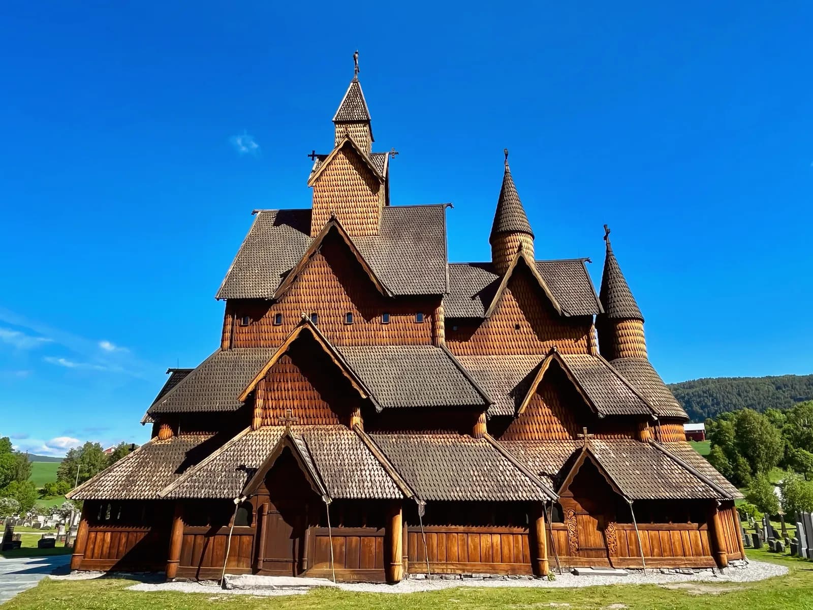
Five kilometres west of the town, by Heddalsvatnet, stands the largest of the 28 stave churches that survive in Norway. It was probably built in the 13th century and is first mentioned, indirectly, in 1315. The church was heavily rebuilt in both the 19th century and the 20th century, so most of the timber has been replaced, but the shape is the old one: roof above roof, rising towards the tower. It is still a parish church.
Don't miss: The short guided tour that is included in the ticket. The church is usually open from mid-May to mid-September, but it may close for periods on Saturdays when there are weddings.
Motorhome tip: The car park is signposted from the E134. Tickets, the café and toilets are in the barn next door. From here, drive west on the E134 to Ørvella and take the Fv 361 north towards Tinnoset.
3. Tinnoset and Tinnsjøen — the deep water
The Fv 361 meets the Fv 37 at Gransherad, around four kilometres south of Tinnoset at the southern end of Tinnsjøen. The railway ferries called here for more than 80 years. From 1909 the fertiliser went from Rjukan by train to Mæl, by ferry across the lake to Tinnoset and on by train to Notodden. The lake is 35 kilometres long and up to 460 metres deep, the third deepest lake in Norway. The Fv 37 follows the water north towards Mæl, through four tunnels from 1992.
Don't miss: The views over the water from the road. Out on the lake the railway ferry D/F «Hydro» was sunk on 20 February 1944, in one of the heavy-water raids. Fourteen Norwegians and four Germans died.
Motorhome tip: Between Tinnoset and Mæl, around 30 kilometres, we found neither a campsite nor a filling station. Fill up in Notodden or at Heddal: from the station on the E134 at Heddal it is around 65 kilometres along the route to the next one, in Rjukan, and around 90 if you drive up to Stavsro first, with a long climb on the way.
4. Mæl — the ferries that wait
At Mæl, at the end of the western arm of Tinnsjøen, train met ferry. The Rjukan railway ran the 16 kilometres from here to Rjukan. Regular traffic on the railway and the lake stopped in 1991, and the ferries were laid up here the same year. Two of them usually lie at the quay: the steam ferry «Ammonia» from 1929 — no larger steamship has ever sailed on a Norwegian lake — and M/F «Storegut» from 1956. Both are protected. The station area is 850 metres long and open every day, free of charge and unstaffed.
Don't miss: A quiet walk along the quay and the tracks. The site is protected, but it has not been made safe for visitors, so keep an eye on children. If you would like a guided tour, you can book one with Norsk Industriarbeidermuseum.
Motorhome tip: There is parking at the station. Tinnsjø Kro & Camping, close by, has its own motorhome area with electricity, water and waste disposal, and the spaces cannot be booked. The museum says that at present neither trains on the Rjukan railway nor boats on Tinnsjøen are running.
5. Gaustatoppen — a view over a sixth of Norway
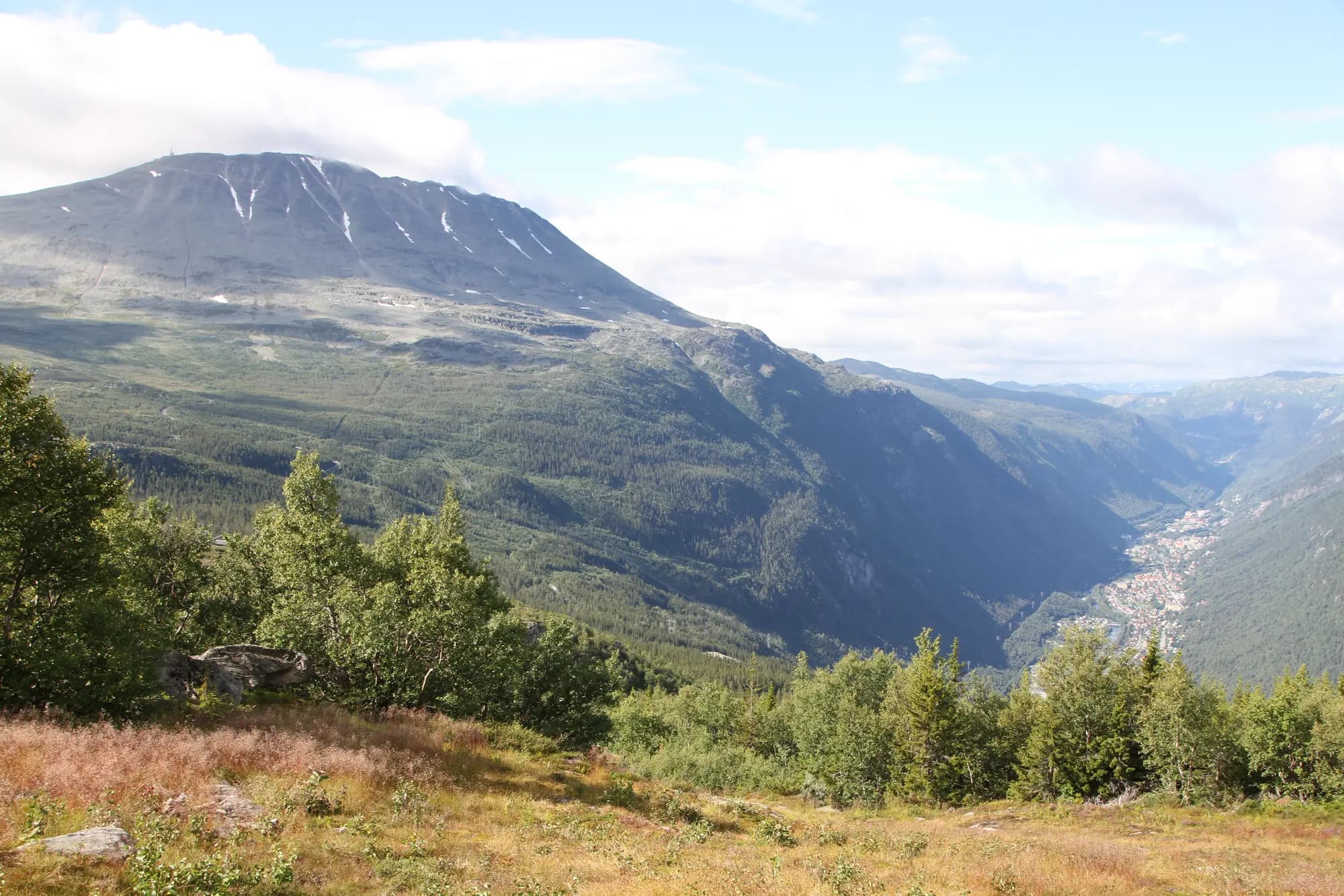
At Dale, before you reach Rjukan, the Fv 3430 turns off to the south and climbs towards Gaustatoppen, 1,883 metres above sea level. It is the highest mountain in Telemark, and on a clear day you can see across about a sixth of the country. Most people walk from Stavsro: around 4.3 kilometres each way and 700 metres of climbing, two to four hours up on a broad, well-marked path. One kilometre south of the highest point is Gaustatoppen turisthytte, a staffed DNT hut from 1893. It usually serves food every day from early February to the autumn half-term in October.
Don't miss: Gaustabanen, a railway built for the military and finished in 1959, opened to tourists in 2010. A battery-powered tram takes you almost a kilometre into the mountain, then a steep railway carries you up to around 1,800 metres, just below the top. The whole trip takes a quarter of an hour. Many people walk up from Stavsro and ride down. It arrives at the lower station, around four kilometres from Stavsro, so take the free shuttle bus back to your vehicle. Gaustabanen runs all year, apart from closures for maintenance, and you do not need to book a ticket in advance.
Motorhome tip: From Dale the Fv 3430 climbs around 900 metres in twelve kilometres. The road is open to vehicles up to 19.5 metres long, but it is steep, in places only around four metres wide, and the shuttle buses use it too. Come down in a low gear and spare your brakes. At the bottom you pass under an overhead line signed at 4.5 metres. With a large motorhome you may prefer to leave it in Rjukan and take the Fjellbussen mountain bus, which is free and runs for much of the year. Parking at Stavsro is charged by the day and paid in the APCOA app or at the machine by the tourist information. Motorhomes may park there by day, but not overnight, and camping is not allowed. In fine weather in high season it can be full. Then you can park at Svineroi, Bygget or Gaustablikk, where there is also a charge, and take the free shuttle bus from there. The road from Svineroi past Stavsro and over to Tuddal is closed in winter, usually from November or December until around the middle of May. There is no filling station up at Gausta.
6. Rjukan — the town in the shadow
Norsk Hydro built Rjukan between 1908 and 1920, and when the town was complete it had around 10,000 inhabitants. The valley is so narrow and the mountains to the south so high that the sun does not reach the town from October to March. That is why the town got Krossobanen in 1928, a cable car meant to carry people up into the sunshine in winter. In 2013 came the sun mirror: three mirrors high on the mountainside on the north side of the valley reflect sunlight down onto the town square.
Don't miss: Ryes veg, the old path up beneath Krossobanen: around four kilometres and 500 metres of climbing in 21 bends. The cable car itself has been closed since June 2024, and its owners are working to reopen it in 2028. From the top station it is 2.8 kilometres, about an hour's walk, to the sun mirror.
Motorhome tip: Rjukan bobilparkering at Såheimsveien 3, close to the centre, has six spaces all year, with electricity and cold water. The spaces cannot be booked. You pay by Vipps, bank transfer or cash and leave the ticket visible in the vehicle. The waste disposal point is between Rjukan hytteby and the stadium, on the east side of town. Fill up in Rjukan before you carry on west.
7. Vemork — the power station and the heavy water
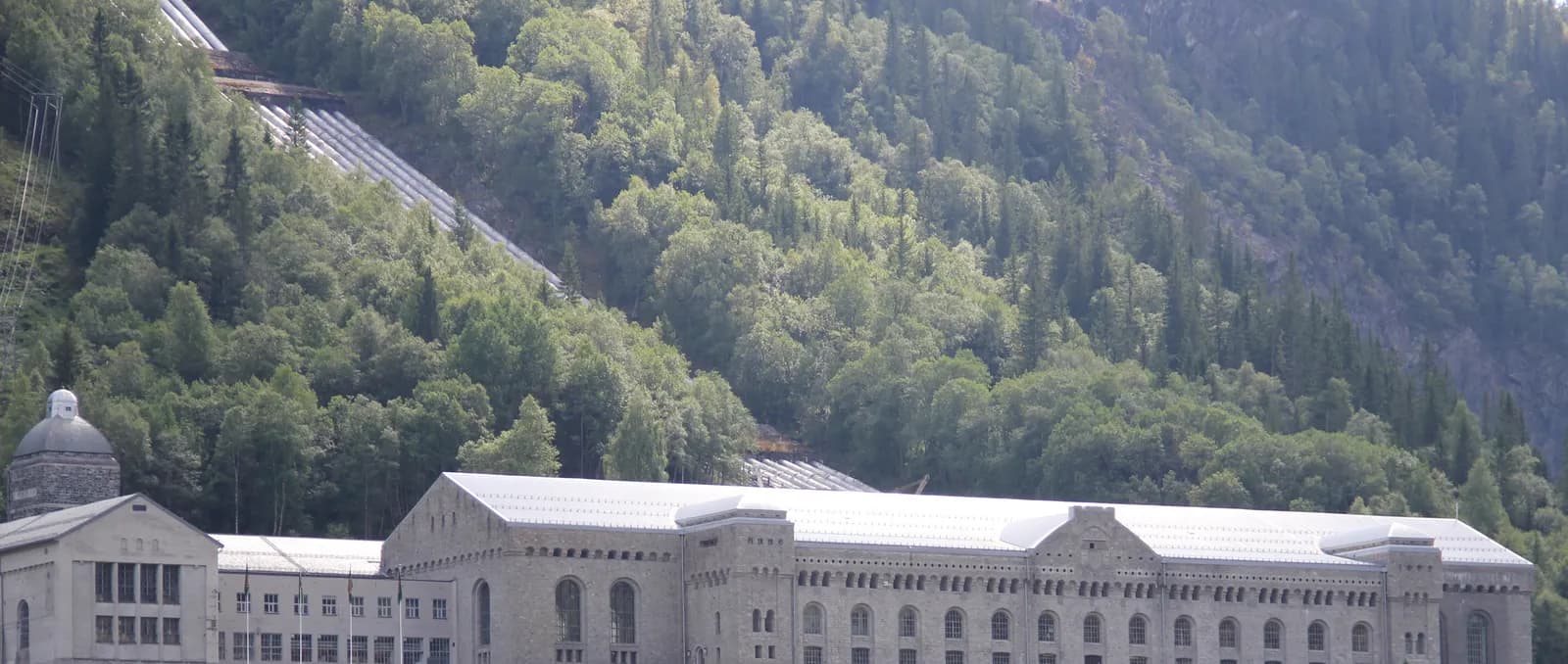
Seven kilometres west of the centre lies Vemork. When the power station was completed in 1911, for a time there was none larger in the world. Since 1988 Norsk Industriarbeidermuseum has been housed in the old station. Heavy water was also made here, and on the night before 28 February 1943 Norwegian saboteurs blew up the heavy-water plant. The museum is open all year: every day in summer, and Tuesday–Sunday in winter.
Don't miss: The exhibition about the heavy water in the basement, which is included in the ticket.
Motorhome tip: You park for a fee down by Vemorkbrua and walk around 800 metres, about twenty minutes with some steep slopes, up to the museum. The museum says the road down to the car park is very narrow, and in summer the traffic there is regulated. Coaches cannot cross the suspension bridge and have to park at Vemorkjuvet. If you have a large motorhome, phone the museum before you drive down. A couple of kilometres west of Vemork the Fv 37 goes through the Maristigen tunnel, signed at 4.2 metres.
8. Møsvatn — where the water comes from
Above Vemork the Fv 37 climbs to Møsvatn, around 900 metres above sea level. It is the largest lake in Telemark, regulated since 1904 and the largest reservoir for the power stations in Rjukan. The water level can vary by almost 20 metres. The dam, Møsvassdammen, is the top end of the World Heritage site. From here the water runs down through Vestfjorddalen, past Vemork and Rjukan, and out into Tinnsjøen.
Don't miss: The boat trip on M/B «Fjellvåken II» from Skinnarbu up to Mogen, at the other end of the lake. It usually runs every day from late June to early September.
Motorhome tip: Between Rjukan and Rauland, around 47 kilometres, there is no filling station. The Fv 37 between Møsvatn and Rauland is a mountain pass with extra winter maintenance. It is open in winter but can close in bad weather. Check vegvesen.no before you set off.
9. Rauland and Åmot — on towards West Telemark
Rauland is a mountain village on the north side of Totak. Rauland church dates from 1803 and has a crucifix from about 1200. The fiddler Myllarguten spent his last years in the area, and his home, Kosi in Arabygdi, is a memorial house today. The University of South-Eastern Norway teaches folk music and folk art here. The Fv 37 carries on south to Åmot, where it meets the E134 and the Fv 38 towards Dalen.
Don't miss: Totak, the lake below the village. It is up to four kilometres wide and more than 300 metres deep.
Motorhome tip: Groven Camping in Åmot, 250 metres from the centre and the E134, has 41 motorhome pitches and its own waste disposal point, from Easter to the end of October. Both Rauland and Åmot have a filling station.
Practical info for motorhomes
Roads: The E134, Fv 361, Fv 37 and Fv 3430 are open to vehicles up to 19.5 metres long and 50 tonnes (Statens vegvesen's road database). The Fv 37 is mostly more than six metres wide all the way. Along Tinnsjøen it runs through four tunnels from 1992; the longest, Presturatunnelen, is just under 1.4 kilometres. The lowest signed height on the route is 4.2 metres, in the Maristigen tunnel near Vemork. At Dale, where the Fv 3430 leaves the Fv 37, an overhead line crosses the road, signed at 4.5 metres. The Fv 3430 up to Stavsro is steep: around 900 metres of climbing in twelve kilometres, and in places only around four metres wide. The road from Svineroi over Stavsro to Tuddal is closed in winter, usually from November or December until around the middle of May, and the Fv 37 between Møsvatn and Rauland can close in bad weather. There are no toll stations on the route. If you come from Oslo on the E134, you pass, among others, two toll stations on the E134 in Kongsberg. Most motorhomes are registered as passenger cars (vehicle group M1) and pay the rate for small vehicles, even above 3.5 tonnes (vegfinans.no). Check vegvesen.no or call 175 before you set off.
Parking: At Stavsro the parking is paid, and it can be full on fine summer days. Then take the shuttle bus from Svineroi, Bygget or Gaustablikk. At Vemork the road down to the car park is very narrow. At Mæl and Heddal stave church there is parking on site. Never park in passing places.
Overnight stays: We have found no local bans on overnight stays in a motorhome in Notodden, Tinn or Vinje. At Stavsro overnight stays and camping are not allowed. The rules of the Outdoor Recreation Act for tents are a sensible guide: at least 150 metres from an inhabited house or cabin, and no more than two days in the same place without the landowner's consent. With a motorhome you stop only where parking is allowed, and you never drive off the road into the terrain. Use the motorhome sites and campsites.
Campsites:
- Notodden Bobilcamp, Nesøya — central, electricity and waste disposal, cannot be booked
- Notodden Camping, Notodden — three kilometres from Heddal stave church
- Tinnsjø Kro & Camping, Mæl — its own motorhome area with electricity, water and waste disposal
- Rjukan Hytte- og Caravanpark, Miland — by the Fv 37 between Mæl and Rjukan, says it is open all year; phone before you come
- Rjukan bobilparkering, Såheimsveien 3 — six spaces all year
- Groven Camping, Åmot — 41 motorhome pitches, Easter–end of October
Fuel: Notodden has many stations, and at Heddal there is one on the E134. Once you leave the E134 there is no station on the route before Rjukan: around 65 kilometres, or around 90 kilometres if you drive up to Stavsro first. There is no station up at Gausta, and between Rjukan and Rauland it is around 47 kilometres without one.
Waste disposal: Notodden Bobilcamp on Nesøya (toilet waste and grey water), Tinnsjø Kro & Camping at Mæl, the disposal point between Rjukan hytteby and the stadium in Rjukan, and Groven Camping in Åmot. We have not found a confirmed disposal point at Møsvatn or in Rauland.
Ferries: None. The railway ferries across Tinnsjøen stopped running regularly in 1991, and today no car ferry runs on the lake. «Ammonia» and «Storegut» lie at Mæl, and Norsk Industriarbeidermuseum says that at present no boats are running on Tinnsjøen.
Combine with
- The Telemark Canal and West Telemark — from Åmot it is around 32 km east on the E134 to Morgedal and around 50 km to Seljord, where that route ends. Drive it in reverse, down to Skien.
- Setesdal and Hovden — from Åmot it is around 40 km west on the E134 to Haukeligrend, and from there around 30 km south on the Rv 9 to Hovden, where that route ends. Drive it in reverse down the valley to Kristiansand.
- Numedal and its stave churches — Kongsberg, where that route starts, is just over 30 km east of Notodden on the E134.
Weather
Notodden has an inland climate with warm summers: the average temperature in July is around 17 degrees, and in January around minus 4.5. February and March are the driest months, and August is the wettest. Rjukan lies in shadow from October to March. The top of Gaustatoppen is almost 1,900 metres above sea level, so bring warm clothes even in summer. Check yr.no for Notodden, Rjukan and Gaustatoppen before you go.
This route is part of Bobilvei's hand-picked motorhome routes in Norway. Every route is quality-checked with a focus on motorhome suitability, parking and local experiences.