- Route
- Trondheim – Orkanger – Lakseveien – Krokstadøra – Hemnskjela – Hitratunnelen – Sandstad – Fillan – Dolmsundet – Frøyatunnelen – Hammarvika – Titran (E6, E39, Fv 714, Fv 716 and Fv 6460), with side trips and a boat to Sula
- Length
- about 175 km from Trondheim to Titran. The side trips to Hemnskjela, Hopsjø, Dolm and Sistranda add around 40 km, and Sistranda–Dyrøy (the boat to Sula) around 33 km there and back. The same way home: about 175 km.
- Driving time
- Around 3 hours from Trondheim to Titran without stops, around 4 with the side trips
- Recommended number of days
- 2–3. Two days are enough for a weekend; if you want to go out to Sula, you need three.
- Best season
- May–September. The roads are open all year, but Stortjønna Camping at Titran is closed from November to March, and the museums keep shorter hours in winter.
- Difficulty
- Easy. Wide county roads, open to vehicle combinations of 19.5 metres, and no ferry on the main route. The two undersea tunnels have long gradients of around ten per cent.
- Last checked
- October 2026
Why this route?
Barely three hours from Torvet, the main square in Trondheim, the road runs out. At the far end of Frøya, in the fishing village of Titran, there is nothing to the west but skerries and open sea. On the way you drive under the sea twice, first through Hitratunnelen, which was the deepest undersea tunnel in the world when it opened in 1994.
The two islands are not alike. Hitra is the largest island in southern Norway, with wide bogs, low hills and so many red deer that you should drive slowly at dusk. Frøya is low and bare, with smooth rock and small lakes. Both live off the sea — and off salmon.
This is a weekend trip out and back. Day one takes you to Hitra: the museum in Fillan, the old trading post at Hopsjø and a night by Dolmsundet. Day two, on to Frøya and Titran. If you have a third day, take the boat out to the fishing village of Sula.
Stops along the route
1. Lakseveien — at the head of Snillfjorden
From Trondheim you follow the E6 and E39 to Orkanger, just over 40 km. Twelve kilometres west of Orkanger, at Stokkhaugen, you turn onto the Fv 714. From here and for around 45 km out to Sunde it is called Lakseveien, the Salmon Road — named after all the salmon lorries that have driven it over the years. Much of it has been rebuilt, and the newest tunnels date from 2013–2021. Just under 20 km in lies Krokstadøra, at the head of Snillfjorden.
Motorhome tip: At Krokstadøra, Orkland municipality has built a dump station by the Fv 714. It is normally open from mid-March to October. Outside the season, empty your tanks and fill up with water in Orkanger, at the OTI centre or at Grønøra. Lakseveien has two toll points, at Våvatnet and at Valslag.
2. Hemnskjela — the fortress island by the tunnel
Just before Hitratunnelen you cross a bridge onto the small island of Hemnskjela. Take a walk here and you will find gun positions and bunkers scattered across the landscape. The island had barely 200 inhabitants when almost 700 German and Austrian soldiers and more than a hundred Russian prisoners of war arrived in 1941. Until barracks were built, the soldiers lived in people's homes, and many families had to give up their house or make do with a single room.
Don't miss: Kystmuseet's war memorial exhibition in the German command bunker, where among other things you can see small gifts the prisoners made for the people who gave them food. You can get inside on scheduled tours in summer or with a booked group; outdoors you can look around at any time of year.
Motorhome tip: The exhibition is just under two kilometres from the Fv 714. The last stretch, Øvre Hemnskjelvei, is almost all gravel.
3. Hitratunnelen and Sandstad — 264 metres below the sea
Hitratunnelen is 5.6 km long and goes 264 metres below Trondheimsleia. You drive around 2.5 km downhill at a gradient of almost ten per cent, and just as far and just as steeply up again on the Hitra side. On both slopes the tunnel has an extra uphill lane, so you can keep right and let others pass.
At the first roundabout after the tunnel, turn right and go down to the fast-boat terminal at Sandstad. Here Kystmuseet has its aquaculture department, with two permanent exhibitions about fish farming and free admission.
Don't miss: The exhibition «Pionerene», about the people who got Norwegian salmon farming started. If you want to see a fish farm up close, Kystmuseet's boat trips leave from here.
Motorhome tip: Shift down and use engine braking on the tunnel slopes, and expect a slow climb in a heavy vehicle. Hitra Camping is in Sandstadvika right by the terminal, with electric hook-ups on the motorhome pitches and a view over the shipping lane. Circle K has an unstaffed fuel pump at Sandstad.
4. Fillan — coastal culture in an old dairy
Seventeen kilometres on is Fillan, Hitra's municipal centre. Kystmuseet i Sør-Trøndelag (the Coastal Museum) has its main building in the old Hitra dairy, and the tourist office for Hitra and Frøya is in the same building. One permanent exhibition takes you into a coastal farm in 1920; the other tells the story of the Russian ship «Jedinorog», wrecked off Hitra in 1760.
Don't miss: «Folket i Flatvika», the coastal farm of 1920. From 20 June to 20 August the museum is open every day; for the rest of the year it is closed on Mondays, and in winter on Tuesdays too.
Motorhome tip: Hitra Bobilparkering is close to the centre, in Leirvågveien, with electricity, water and waste disposal. Pitches are booked through Campio. Fill up in Fillan: St1 has a pump open around the clock.
5. Hopsjø — the trading post (side trip)
Just before Dolmsundbrua, the Fv 6456 turns off to the west, and after just under six kilometres you reach Hopsjø. The trading post by Melandsjøen was founded around 1730 and stayed in business until 1953. Under Nils Rosing Parelius (1753–1799) its own vessels carried fish from here to Spain and France, and the trading house became known far beyond Hitra. Today the wharves are a centre for coastal culture. Hopsjø itself counts the krambu, the old general store, as one of the oldest in the country, and it is still a shop.
Don't miss: The whaling museum and the story of the canning industry, and dinner in the restaurant in the old warehouse.
Motorhome tip: The Fv 6456 is around five metres wide, narrower than the main road, so take it easy when you meet oncoming traffic. The krambu is open every day in summer; out of season, check hopsjo.no before you go.
6. Dolm — the medieval church on Dolmøya (side trip)
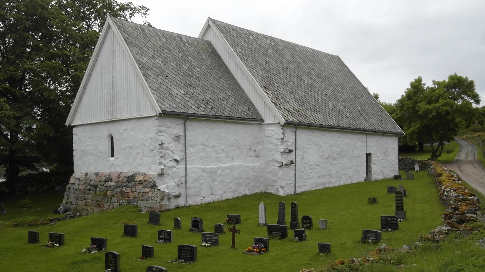
Dolmsundbrua takes you across the narrow sound to Dolmøya. Nobody knows for sure how old Dolm Church is: local tradition on Hitra says the 1100s, while scholars lean towards the 1400s. Either way, the whitewashed stone church in the south-west of the island is the only medieval building on Hitra and Frøya. After a fire in 1920 Hitra got a new main church, and Dolm was not consecrated again until 1992. Three marked trails lead from the church out into the cultural landscape, and in the old vicarage garden there are broadleaf trees more than 200 years old.
Don't miss: An evening walk in the vicarage garden. The garden and the trails are open all year. You can only see inside the church on a tour booked with Kystmuseet, and these are designed for groups.
Motorhome tip: Follow the signs for Dolm kirke from the Fv 714 on Dolmøya, around eight kilometres. The last couple of kilometres of the county road are only around 4.5 metres wide, and the final stretch to the church is a municipal road open to vehicle combinations of 15 metres. For the night: Dolmsundet Marina, right by Dolmsundbrua, has eight motorhome pitches with electricity, and a shower and toilet in the main building. Book by email.
7. Frøyatunnelen and Sistranda
From Dolmøya, Frøyatunnelen runs 5.3 km under Frøyfjorden, down to 164 metres below the sea, and comes up at Hammarvika. The descent from the Hitra side and the last kilometre up are both almost ten per cent steep. Four kilometres north is Sistranda, Frøya's municipal centre, with shops and fuel.
Don't miss: Frøya bygdetun, the open-air farm museum by the sea at Sistranda, with Dalastua, a house from the first half of the 1800s. The yard is open to all, and the houses open on Tuesdays in midsummer.
Motorhome tip: The dump station on Frøya is free and run by Frøya Transportsenter in Hamarvik industrial park, a little way off the main road, not far from the tunnel. Sistranda bobilcamp at Rabben Marina has eight pitches with electricity and a service building, and you pay on site.
8. Sula — the fishing village out at sea (side trip by boat)
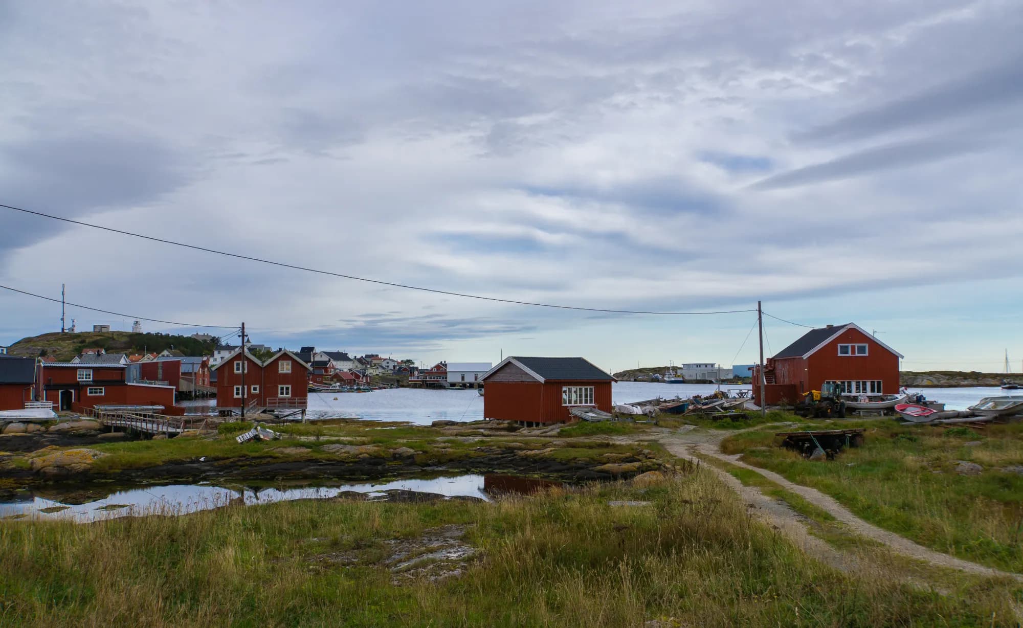
From the quay at Dyrøy, around 16 km by road north-west of Sistranda, a ferry and a fast boat go out to the chain of islands. In its heyday more than 500 people lived on Sula; now around 60 live there all year, and only in summer do the houses fill up again. The village is built on four small islands joined by short bridges, and the lighthouse stands on the knoll above the harbour.
Don't miss: The fishing village museum in the community hall, open all year.
Motorhome tip: Leave the motorhome at the quay at Dyrøy and take the fast boat (route 820, in summer also 821). It docks in the middle of the village and takes around 20–25 minutes when it goes direct. The car ferry (route 825) takes 24 cars and goes to the ferry quay a couple of kilometres outside the village, and the road from there is narrow gravel. If you still want to bring the motorhome, Sula havcamping has electricity, a service room and a dump station.
9. Titran — where the road ends
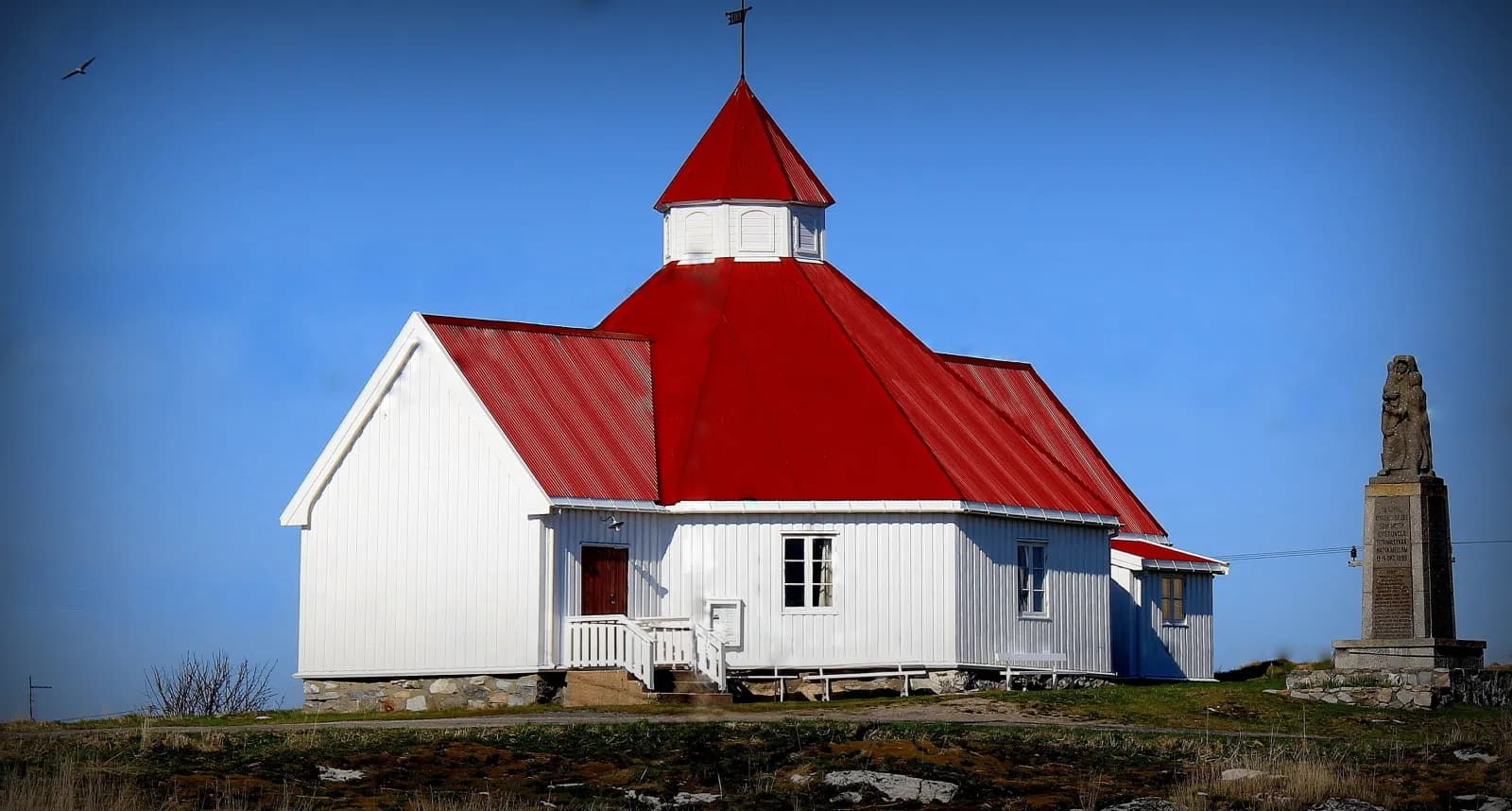
From Hammarvika it is 30 km west on the Fv 716 and Fv 6460 to Titran, at the far end of Frøya. In the autumn of 1899 many boats were out fishing for herring off Titran when a hurricane struck in the night before 14 October. 140 fishermen never came home. The memorial from 1949 stands by the chapel, which was built as a prayer house in 1873. Out at sea you can see Sletringen lighthouse. Its tower is 45 metres tall, taller than any other lighthouse on the Norwegian coast.
A short way south of the houses you can walk freely around much of Stabben Fort, out onto the rocks and down into the passages underground. Around 150 prisoners of war from Russia and Serbia were forced to build the fort for the Germans, from the spring of 1941.
Don't miss: The evening light over the skerries from Stabben.
Motorhome tip: According to Frøya municipality, Stortjønna Camping at Titran has room for around 20 motorhomes and caravans, with electricity, showers, toilets and a kitchen, and is open from April to October. It is worth phoning before you drive out. The road there is mostly 5.5–6.5 metres wide.
Practical info for motorhomes
Roads: All the county roads on the route, including the side trips to Hopsjø, Dolm and Dyrøy, are paved and open to vehicle combinations of 19.5 metres (the road database of the Norwegian Public Roads Administration). The Fv 714 is mostly 6–7 metres wide, and in Hitratunnelen there are nine metres between the edges. The side roads are narrower, around five metres, with sections down to around four. The last stretch to Dolm Church is a municipal road for vehicle combinations of up to 15 metres, and the road to the war memorial exhibition on Hemnskjela is mostly gravel. The lowest calculated clearance on the route is 4.2 metres, in Brattstiåstunnelen on Lakseveien; in the two undersea tunnels it is 4.5. That is enough for an ordinary motorhome. No mountain passes, no roads closed in winter. Both undersea tunnels are on the list of tunnels you can get alerts for in the Vegvesen trafikk app; no bridge on the route is. Even so, Frøya lies low and open to the sea, so a tall motorhome will feel the wind. Check vegvesen.no before you set off.
Parking: There is parking at the museum in Fillan, at the terminal at Sandstad, at Hopsjø and by Dolm Church. Never park in passing places.
Overnight stays: The police by-laws in both Hitra and Frøya ban tents, camping and the like in public parks, green spaces and open areas and on, beside or under roads and squares in built-up areas, unless signs say otherwise. In parks, green spaces and open areas it is also forbidden to drive and park motor vehicles without signs that allow it. The Outdoor Recreation Act lets you pitch a tent on uncultivated land (utmark) at least 150 metres from an inhabited house or cabin, for at most two nights in the same place without the landowner's consent. It gives no right to park a motorhome; there, the signs and the landowner's rules apply. Never drive off the road into the terrain. Use the motorhome sites.
Campsites:
- Hitra Camping — Sandstadvika by Hitratunnelen, motorhome pitches with electricity
- Hitra Bobilparkering — Fillan, electricity, water and waste disposal, booked through Campio
- Dolmsundet Marina — by Dolmsundet, eight motorhome pitches with electricity, booked by email
- Sistranda bobilcamp — at Rabben Marina in Sistranda, eight pitches with electricity, pay on site
- Stortjønna Camping — Titran, around 20 pitches, April–October
Fuel: Orkanger has several stations. On Hitra there is fuel at Sandstad, in Fillan and by Dolmsundet, among other places; on Frøya you will find it at Sistranda. Fill up before you drive out to Titran.
Waste disposal: In Orkanger (at the OTI centre and at Grønøra), at Krokstadøra (usually mid-March–October), at Hitra Bobilparkering in Fillan (for guests), at Frøya Transportsenter in Hammarvika and at Sula havcamping (for guests).
Tolls: Lakseveien has two toll points, Våvatnet and Valslag, and you pass several more on the way out of Trondheim. Without an AutoPASS agreement the bill goes to the owner. A motorhome over 3,500 kg pays the car rate on Lakseveien only with an agreement and a tag, and only when it is registered as M1 with the tag issuer. Agree with the owner how you will settle up.
Ferries: No ferries on the main route. To Sula, Mausund and the other islands, route 820 (fast boat, in summer also 821) and route 825 (car ferry) run from Dyrøy, operated by Torghatten for AtB. The car ferry takes around 40 minutes direct to Sula. The fast boat takes 20–25 minutes on the direct run, around 50 minutes or more when it calls at the other islands. AtB counts the service among its free ferries, but from 1 June to 31 August vehicles pay a summer fare. Timetables at atb.no.
Combine with
- Fosen and the Trøndelag coast — the Fosen loop heads home on the Brekstad–Valset ferry. From Valset it is around 115 km via Orkanger to Sandstad on Hitra.
- Atlanterhavsvegen — from Sandstad it is around 185 km to Kristiansund along the coast through Hemne and Aure, with the Tømmervåg–Seivika ferry, and from there around 30 km through Atlanterhavstunnelen to Kårvåg, the end point of that route.
- Trondheim – Røros — the same start in Trondheim, but inland: up Gauldalen to the old mining town.
Weather
The sea keeps the winters mild: at the weather station on Sula, far out in the island chain, the January normal is above three degrees. Summer is cool, with a daily mean of around 13–14 degrees in July and August. May is the driest month, while from September to December around 100 millimetres falls each month. By the sea it is often breezy — in January 2025 Sula recorded gusts of more than 40 metres per second. Check yr.no for Fillan, Sistranda and Titran.
This route is part of Bobilvei's hand-picked motorhome routes in Norway. Every route is quality-checked with a focus on motorhome suitability, parking and local experiences.