- Route
- Trondheim – Flakk–Rørvik (ferry) – Stadsbygd – Rissa – Åfjord – Bjugn – Austrått – Uthaug – Brekstad – Brekstad–Valset (ferry) – Orkanger – Trondheim (Fv 717, 718, 720, 715, 710, E39, E6), with detours to Råkvåg and Stokkøya
- Length
- about 285 km around the loop, including both ferries. Råkvåg adds around 20 km and Stokkøya around 70 km return.
- Driving time
- 6–7 hours for the whole loop, including two 25-minute ferries, plus waiting at the quays
- Recommended number of days
- 2–3. Two days make a weekend; for Stokkøya you need three.
- Best season
- June–August. The gun turret has summer tours, Austråttborgen from July to mid-August. Roads are open all year.
- Difficulty
- Easy. Almost entirely paved, open to 19.5-metre vehicle combinations, with no mountain passes. Two unbookable ferries and a narrow road on Stokkøya.
- Last checked
- October 2026
Why this route?
From Torvet in Trondheim it is around twenty minutes to Flakk ferry quay. Half an hour later you roll ashore on Fosen, and the city feels far away. The peninsula has an abbey ruin, a manor where Ibsen let Lady Inger rule, a German battleship gun turret, a red lighthouse out at sea and tidal flats where migrating birds rest.
This is a loop: out on Flakk–Rørvik, home on Brekstad–Valset and the E39 via Orkanger. Two days suffice — Åfjord and a night at Austrått on the first, the lighthouse, birds and ferry home on the second. With another day, include Stokkøya.
To avoid ferries entirely, you must go around the fjord over Skarnsundbrua: around 190 km to Rissa instead of 40 by ferry. The route via Orkanger also ends with a ferry, from Valset.
Stops along the route
1. Flakk–Rørvik — across the fjord
The ferry runs roughly every half-hour in daytime and takes 25 minutes. Motorhome fares depend on length: under 6 metres, 6–12 metres or over 12 metres.
Motorhome tip: You cannot book — if it is full, wait for the next one. Arriving late on Friday, Flakk Camping is beside the quay, open May–August without advance booking. You may hear ferry traffic.
2. Stadsbygd — where åfjordsbåter are still built
Around ten kilometres from Rørvik, down by the sea in Stadsbygd, lies Museet Kystens Arv. It still builds åfjordsbåter, the light, slender clinker-built boats that people of Trøndelag have rowed and sailed for over 200 years. The Nordic clinker boat tradition has been on UNESCO's intangible cultural heritage list since 2021.
Don't miss: The boatyard, where new boats take shape using old methods. In autumn 2026 the museum was open Tuesday–Sunday; check kystensarv.no.
Motorhome tip: Follow museum signs from the roundabout on Fv 717 in Stadsbygd — GPS may suggest a narrow shortcut via Trongveien. The last 500 metres down to the museum are around 4.5 metres wide, and Statens vegvesen records the final stretch as gravel.
3. Rissa — the abbey and the landslide
At Rein, a couple of kilometres southwest of central Rissa, Duke Skule founded a convent between 1226 and 1230. The abbey church ruins now stand against the farm's main building. Remember one name: in the early 1530s Lady Ingerd Ottesdatter of Austrått took charge of the convent. You meet her again at stop 7.
Just under two kilometres east, on Fissøya farm, the Rissa landslide began on 29 April 1978. Excavation by a farm building triggered a quick-clay slide that carried farms and houses towards Botn lake. One person died. No clay landslide in 20th-century Norway was larger.
Don't miss: A walk in the park around the abbey. Access is free, and information boards tell the story.
Motorhome tip: Park at Rein church a stone's throw away and fill up in Rissa. Continue on Fv 718 along Botn, Fv 720 through Skaugdalen and Fv 715 north.
4. Råkvåg — the wharves at the head of Stjørnfjorden (detour)
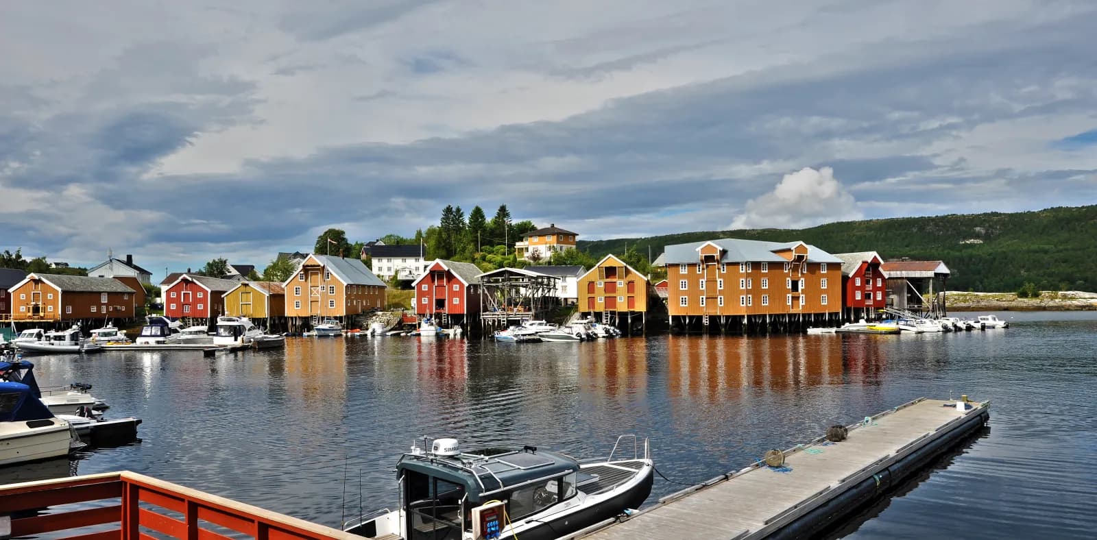
At Rødsjø, three kilometres before Krinsvatn, Fv 718 branches west. Follow signs to Råkvåg for around ten kilometres. The long row of waterfront warehouses remains from around 1900, when herring brought prosperity to the village.
Don't miss: Bryggeutstillinga, an art exhibition with works for sale by the wharves, open daily in summer (20 June–22 August in 2026).
Motorhome tip: The road in from Fv 718 is 5–6 metres wide. Beyond the centre it narrows: west along the sea to around 4.5 metres, north to under four metres before ending at a dead end. Walk along the wharves and drive back the way you came.
5. Åfjord — home of the åfjordsbåt
From Krinsvatn it is twenty kilometres north to Å, or Årnes, where two salmon rivers flow into Åfjorden. The boat you saw in Stadsbygd takes its name from here. At its peak around 1900, Åfjord built about a thousand new boats a year. Fredmoen, the house an English salmon angler bought in 1910, is now a museum.
Motorhome tip: YX in Åfjord sells fuel around the clock. From here Fv 723 heads towards Stokkøya.
6. Stokkøya — sand and sea buckthorn (detour)
Around 35 km from Årnes, through two new tunnels and over Stokkøybrua from 2000, you reach the open sea. Northbound Hurtigruten sails through the narrow sound under the bridge. On the island's western side lies Hosnasanden, with drifting sand and one of Norway's largest sea buckthorn populations, protected since 1987.
Motorhome tip: The road across the island is mostly 4–5 metres wide, often under 4.5 — be ready to give way. There is beach parking, but camping in the protected area is forbidden. Stay at Stoksund Seapark on the mainland south of the bridge, with motorhome pitches, toilets and showers.
7. Austrått — the manor and the gun
Back at Krinsvatn take Fv 710 west to Bjugn, called Botngård until 2019, and onto flat Ørlandet.
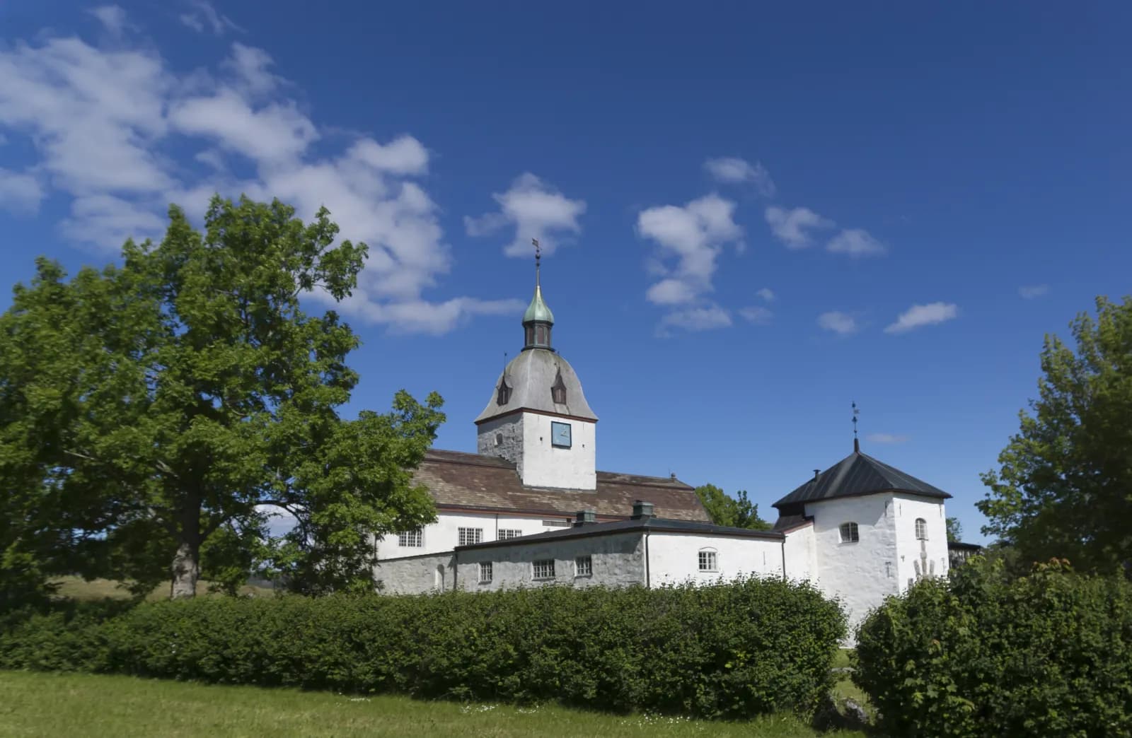
Austråttborgen's chapel dates from around 1200. Lady Ingerd ran the estate in the 16th century, and Henrik Ibsen made her the lead character in “Lady Inger of Østråt”. Ove Bjelke rebuilt the manor in the 17th century; the supporting female figures, caryatids, in the courtyard and noble coats of arms around the gate date from his time. After a fire in 1916 only the walls remained, and three years later the ruin became state property.
Just over a kilometre west stands Austrått fort, with a 28 cm triple gun turret from the battleship “Gneisenau” and five underground levels. Its builders included prisoners of war from Serbia and the Soviet Union. Several dozen prisoners died, and a memorial stands where the camp was.
Don't miss: The tours. You can see the chapel and halls only with a guide; in 2026 the manor was open Thursday–Sunday from 2 July to 16 August. The gun turret has summer tours, and the fort's grounds are open all year.
Motorhome tip: Fill up with diesel in Bjugn. There is manor parking, but from Austrått Camping og Motel, 500 metres away, you might as well walk. The campsite has electricity and a dump station but lists no season — call before arriving.
8. Uthaug and Kjeungskjær fyr — the red seafarer
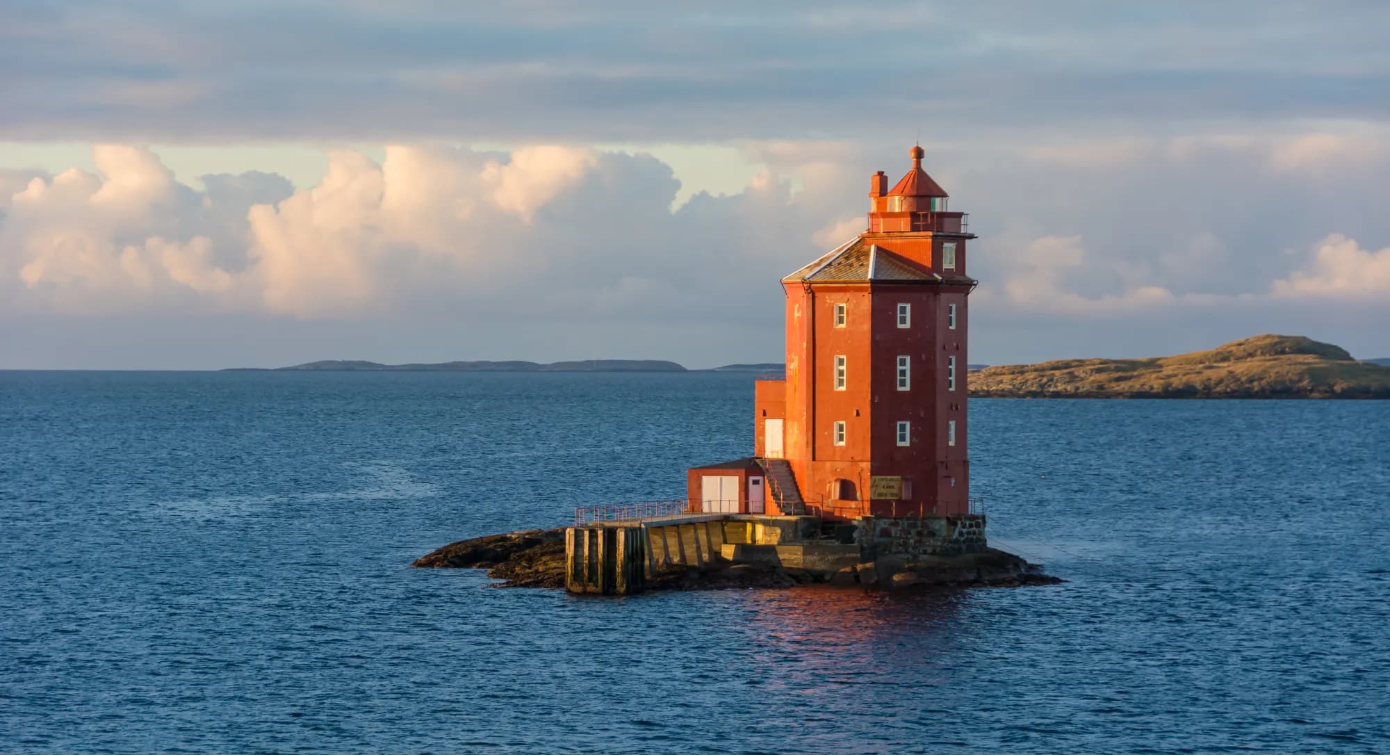
From Uthaug harbour you see the lighthouse three kilometres offshore. Kjeungskjær fyr was first lit in 1880. The tower is so broad that it almost fills its skerry, and at high tide stands directly in the sea. Only one other lighthouse along the coast is octagonal. In 1943 a mine drifted towards it. The keeper pushed it away with a boathook, and it exploded against Uthaug's breakwater instead. You can still see the mark.
Don't miss: A boat trip to the lighthouse with Kjeungen kystlag, which takes groups of at least five for summer tours.
Motorhome tip: Camping on and beside roads and open spaces in built-up areas of Ørland is forbidden unless signs say otherwise. Stay at the campsite at Austrått, nine kilometres away.
9. Grandefjæra and Brekstad — birds and the ferry home
Grandefjæra lies on western Ørlandet. At low tide great mudbanks emerge, resting places for migrating birds travelling north and south. Ørland's wetlands have recorded 235 bird species. The reserve was protected in 1983 and belongs to a Ramsar site. Behind a 2.5 km embankment lies farmland that was tidal shore until drainage in 1957–1967.
Don't miss: The bird tower at Grandefjæra and Besøkssenter våtmark Ørland in Brekstad's cultural centre, one of six authorised wetland centres in Norway.
Motorhome tip: Dogs must not run loose in the reserve. Near Brekstad is Ørland air station, the main F-35 base — you will hear it. From Valset it is 55 km on Fv 710 to Orkanger and the E39.
Practical info for motorhomes
Roads: The entire loop is paved except the final stretch down to Kystens Arv, recorded as gravel by Statens vegvesen. All county roads, including the side roads to Råkvåg and Stokkøya, allow vehicle combinations of 19.5 metres (Statens vegvesen's road database). Main roads are around 6–7 metres wide, minor roads on Ørlandet 5–6. Narrowest are Fv 6320 across Stokkøya, mostly 4–5 metres, and the roads beyond central Råkvåg. The lowest signed height is 4.1 metres in Kalurdaltunnelen on Fv 710 between Valset and Orkanger; tunnels towards Stokkøya are signed at 4.6 metres. No roads are mountain passes, and hills are short. Check vegvesen.no/trafikk before driving.
Parking: Parking is available at Rein church, Austråttborgen and Grandefjæra's bird tower. Space is tight along Råkvåg's wharves. Never park in passing places.
Overnight stays: The Outdoor Recreation Act allows tents on uncultivated land at least 150 metres from an inhabited house or cabin, for at most two nights in one place without the landowner's consent. It gives no right to park a motorhome; signs and landowner rules apply. Ørland's local police by-law bans camping in built-up areas unless signs say otherwise. Never drive off-road into the terrain. Use campsites.
Campsites:
- Flakk Camping — beside Flakk ferry quay, May–August, no advance booking
- Austrått Camping og Motel — by Austråttborgen, electricity and dump station; no season listed, call first
- Stoksund Seapark — motorhome pitches in Stoksund, on the mainland south of Stokkøybrua, open all year, book through Campio
Fuel: YX in Rissa, Åfjord and Bjugn sells fuel around the clock, and Circle K has a 24-hour automated pump in Rissa. Brekstad has Circle K, and Orkanger has several stations on the return journey.
Waste disposal: Austrått Camping has its own dump station, and Flakk Camping accepts guests' cassette and grey water. Fill water where you stay.
Toll roads: Fv 715 has a toll point just south of Krinsvatn, and on the return you pass toll points approaching Trondheim. The ferry fare includes the toll surcharge. Without an AutoPASS agreement the bill goes to the owner; a motorhome over 3.5 tonnes pays the car rate only with an agreement and tag and registration as M1 with the tag issuer. Agree with the owner how to settle up.
Ferries:
- Flakk–Rørvik — about 25 min, roughly every half-hour in daytime (Torghatten Midt for AtB)
- Brekstad–Valset — about 25 min (Fjord1 for AtB)
Neither can be booked. Vehicle fares depend on length, paid with AutoPASS; without AutoPASS or ferrypay.no registration, the owner receives a postal invoice with a fee. Summer fares apply from 1 June to 31 August. Timetables at atb.no.
Combine with
- Trondheim – Røros — the inland alternative with the same start: up Gauldalen to the mining town and home over the mountains.
- Atlanterhavsvegen — from Orkanger, the E39 and Rv 70 head west to Kristiansund, around 150 km including the Halsa–Kanestraum ferry.
- Osen — for further north, Fv 715 continues from Åfjord to Osen, around 60 km.
- Hitra and Frøya — from Valset it is around 115 km via Orkanger to Sandstad on Hitra.
- Inderøy and Den Gyldne Omvei — the fjord loop returns via the Fosen side on Rørvik–Flakk; Rørvik is eight kilometres from Vanvikan.
Weather
The sea keeps winters mild: Ørland's January normal is around one degree above zero. Summers are cool, with a daily mean around 14 degrees in July and August. May is driest. Autumn and early winter are wettest, with around 100 millimetres of precipitation monthly from September to December. The landscape is flat and open to the sea, so expect wind. Check yr.no for Brekstad, Uthaug and Åfjord.
This route is part of Bobilvei's hand-picked motorhome routes in Norway. Every route is quality-checked with a focus on motorhome suitability, parking and local experiences.