- Route
- Balestrand – Dragsvik – Vetlefjorden – Utsikten – Gaularfjellet – Likholefossen – Viksdalen – Sande – Førde (Fv 55, Fv 613 and Fv 610 including Norwegian Scenic Route Gaularfjellet, and the E39 for the final stretch)
- Length
- about 105 km from Balestrand to Førde, about 85 km to the E39 at Sande. Bergen to Balestrand is about 200 km, either via Voss and Vikafjellet with the ferry from Vangsnes or along the E39 with Oppedal–Lavik. Returning to Bergen, turn south on the E39 at Sande: about 150 km. The whole loop from Bergen is around 430 km.
- Driving time
- Around 2 hours without stops from Balestrand to Førde, and about 4 hours from Bergen to Balestrand including a ferry
- Recommended number of days
- 2–3. With a boat trip to Fjærland you need three.
- Best season
- May–September. The mountain road between Mel and Mjell closes for winter. In previous years it closed between 20 November and 3 January and opened between 27 March and 2 May. The Fjærland boat runs from 20 May to 30 September. Check vegvesen.no before driving.
- Difficulty
- Moderate. No length limit, but tight bends and around 7–8 % uphill from Vetlefjorden, with narrow sections along the fjord, on the climb and down Viksdalen.
- Last checked
- October 2026
Why this route?
Gaularfjellet is not the first scenic route people name when talking about western Norway. Yet it has everything: hairpins, a viewing platform above the valley and a river plunging down fall after fall towards Sunnfjord. Before climbing, you get Balestrand: a fjord village welcoming tourists since the second half of the 19th century — many English, and one the German emperor.
The route deliberately runs south to north. You take the bends below Utsikten uphill, using the engine, rather than braking down them. From Bergen it makes a loop with almost no repeated roads: over Vikafjellet, ferry to Balestrand, over Gaularfjellet and home along the E39.
Stops along the route
1. Balestrand — the wooden hotel beside the fjord
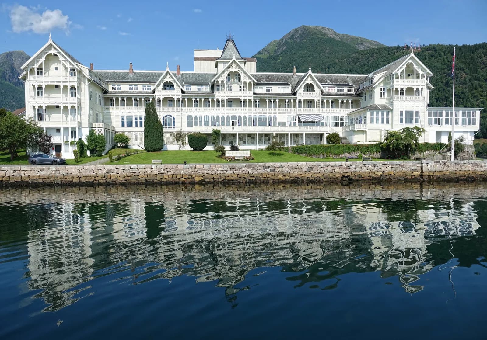
The Kvikne family took over the inn at Holmen in 1877, and the great white hotel was completed in 1913 — one of Norway's largest wooden buildings. German emperor Wilhelm II returned to Sogn summer after summer before the First World War. On 25 July 1914 he was visiting painter Hans Dahl in Balestrand when he learned that Europe was on the brink of war. Many surrounding houses are in Swiss chalet style from around 1900 — carved gables, verandas and pale wooden walls.
Don't miss: Kong Bele on Balehaugane, burial mounds from around 800. The emperor erected the statue in 1913. That same year he gave Vangsnes across the fjord the twelve-metre Fridtjov statue.
Motorhome tip: Fill up at the 24-hour automated pump in the centre — it is the last station before the E39. Nasjonale turistveger also points to a dump station in Balestrand. Stay at Veganeset Camping by Dragsvik ferry quay, nine kilometres by road from the centre. Coming from Høyanger, Fv 55 tunnels have signed heights down to 4.2 metres — the last, Kræklingentunnelen, is just before the centre.
2. St. Olafs church — the English church
The church commemorates a woman. English climber Margaret Sophia Green married into the Kvikne family but contracted tuberculosis and died in 1894. She had wanted an English church in Balestrand. Her husband Knut Kvikne donated land from the hotel grounds, and in 1897 it stood here: dark brown with yellow trim, built to resemble a stave church.
Don't miss: Look towards the roof ridge. Two dragons stand guard at the top, borrowed from stave churches.
3. Fjærland — the fjord and glacier by boat
A sightseeing boat sails from Balestrand into Fjærlandsfjorden in summer, from 20 May to 30 September. At Fjærland a bus takes you to Norsk Bremuseum and on to Bøyabreen. The museum was designed by Sverre Fehn and opened in 1991. Bøyabreen is now only a small remnant of what it was, so come more for the valley and museum than the ice.
Don't miss: Bokbyen in Mundal, with hundreds of thousands of used books for sale in summer.
Motorhome tip: Leave the motorhome and take the boat. By road Fjærland is over 80 km away, including a ferry and a detour via Sogndal. The outing takes most of the day, so arrange all-day parking where you stay. Never walk onto the glacier without a guide.
4. Vetlefjorden — beside the fjord to Mel
From Dragsvik, Fv 613 follows the western shore of Fjærlandsfjorden and enters narrow Vetlefjorden. It is a quiet stretch, with farms sloping to the water. The mountainsides are prone to rockfalls and avalanches, and two short tunnels and an avalanche shelter protect the road.
Motorhome tip: The road is mostly around 5.5 metres wide, but between Dragsvik and Utsikten a total of around two kilometres is narrower than 4.5 metres, the narrowest below 3.5. Use passing places. The tunnels are signed at 4.5 metres and the Ramsteina avalanche shelter at 4.3. A couple of kilometres above Mel is the winter closure barrier.
5. Utsikten — above the bends
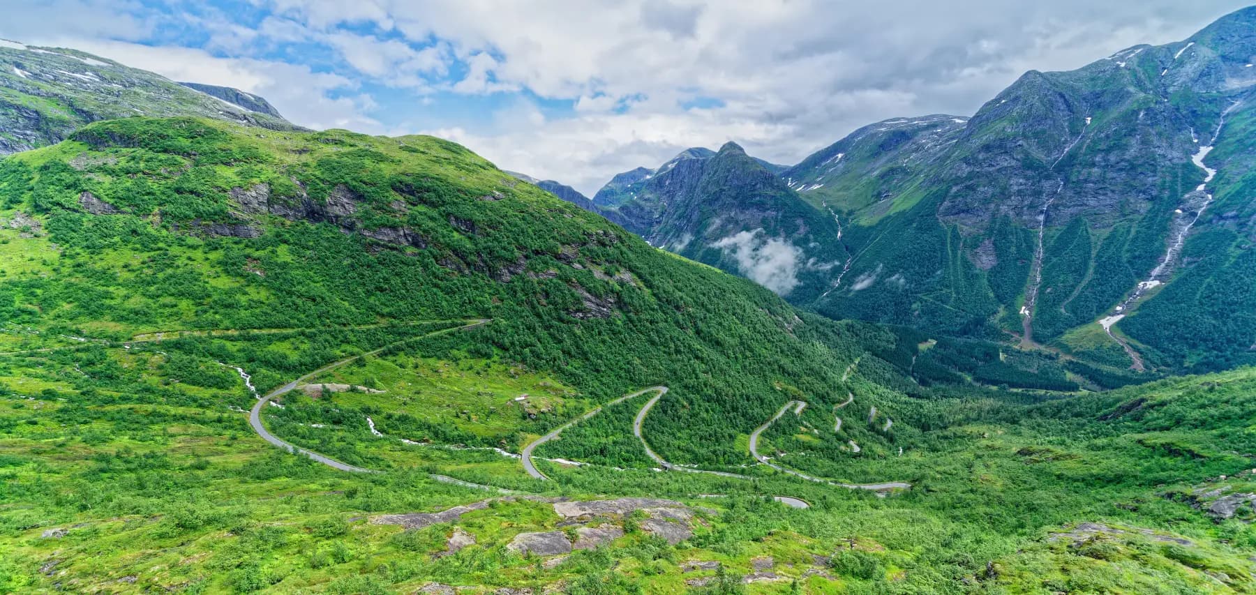
From Mel the road climbs over 600 vertical metres in eight–nine kilometres, bend after bend up the hillside. At the top, 700 metres above sea level, the platform projects from the mountainside. From here you see the road you just drove down in the valley. Utsikten was designed by Code arkitektur and opened in 2016.
Don't miss: Walk onto the platform and look down at the bends.
Motorhome tip: Almost a kilometre of the winding climb from Mel is narrower than 4.5 metres, around 3.5 at its narrowest. A sign warns descending drivers of an 8 % gradient. Climb in low gear, look well ahead and wait for oncoming traffic before a sharp bend rather than in it. The car park is not large. Toilets are open from May to late October.
6. Torsnesstølen — a well in the mountains
Up on the mountain, just over 740 metres at its highest, the landscape opens, with small lakes beside the road. At Torsnesstølen stands Marianne Heier's “Mirage”: a well on a mountain seldom short of rain. The artwork has nine counterparts in Malawi, built with UNICEF — ten wells in total.
Motorhome tip: Fossestien's car park has seven car spaces. The rest area by Nystølsvatnet, just before it, is an alternative.
7. Likholefossen — the bridge over the waterfall
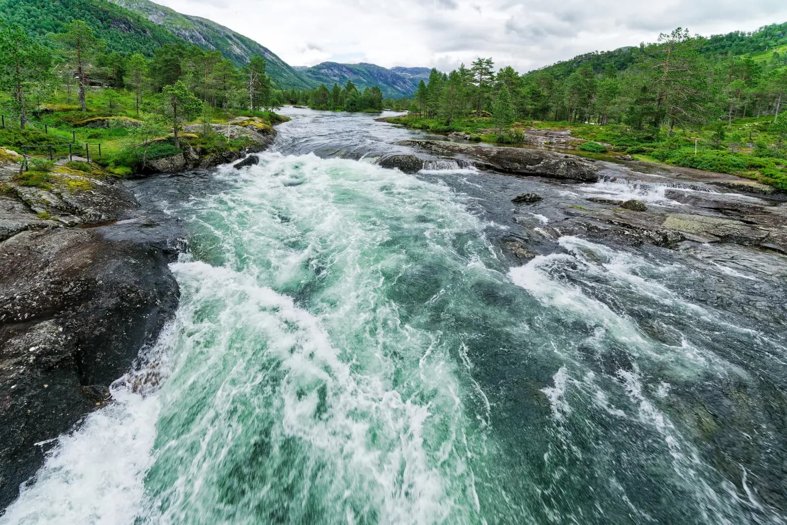
From here the road follows the river downhill. Gaularvassdraget is protected against hydropower development, so the river flows freely. At Likholefossen a steel bridge crosses the waterfall, with water thundering beneath your feet. Fossestien runs 21 km beside the river, past 14 waterfalls and 7 lakes, down to Viksdalen.
Don't miss: A section of Fossestien, at least as far as the next waterfall.
Motorhome tip: The rest area has seven car spaces, none marked for large vehicles. There are two more parking areas nearby, one beside the road. Come early or late in the day.
8. Viksdalen and Hestad — the lake and chapel
At Eldalsosen take Fv 610 west along Viksdalsvatnet. At Hestad rest area, stretch your legs on a walkway over the water. A little further stands Hestad chapel, a tarred timber chapel from 1805. Tradition says it was built partly from material from a medieval stave church on this site. Fortidsminneforeningen manages the chapel.
Motorhome tip: Fv 610 has many narrow-road warnings, and just over a kilometre and a half is narrower than 4.5 metres. Two 3.4-metre height signs at Kirkeli apply to a bridge on the side road, not Fv 610. Going straight to Førde, Fv 613 over Rørvikfjellet and via Holsen to Moskog is slightly shorter but also narrow in places. The rest area is low beside the lake and can flood.
9. Eikelandsfossen and Sande — down to the E39
Just before Sande lies Eikelandsfossen, with its own roadside rest area. At Sande you meet the E39. Bergen lies south, Førde, the town in Sunnfjord, north.
Motorhome tip: Førde Gjestehus og Camping lies beside the Jølstra, 200 metres from the E39, and is open all year. Even non-guests can empty a toilet cassette in its machine for a fee.
Practical info for motorhomes
Roads: Fv 55, Fv 613 and Fv 610 all allow vehicle combinations of 19.5 metres (Statens vegvesen's road database), so this route has no separate length limit. Fv 613 and Fv 610 are mostly 5–6 metres wide but narrow to 3.4 metres in places: from Dragsvik to Utsikten around two kilometres are below 4.5 metres, and down Viksdalen just over a kilometre and a half. Across the plateau itself the road is more consistent. The lowest signed height on the actual route is 4.3 metres at the Ramsteina avalanche shelter; Fv 55 tunnels into Balestrand from Høyanger are signed down to 4.2 metres. The mountain between Mel and Mjell closes for winter, with dates varying annually. Shortly after spring opening, night and bad-weather closures can occur. Check vegvesen.no/trafikk or call 175.
Parking: Mountain rest areas are designed for cars. Never park in passing places, and do not stop for photos on the bends below Utsikten.
Overnight stays: Use campsites. The right to roam (Outdoor Recreation Act section 9) concerns tents and outdoor stays: at least 150 metres from an inhabited house or cabin and at most two nights in one place without the landowner's consent, except in high mountains or far from buildings. Signs and landowner rules apply to motorhomes. Never drive off-road into the terrain.
Campsites:
- Veganeset Camping — Dragsvik, beside the ferry quay, 1 May–1 October
- Førde Gjestehus og Camping — Førde, beside the Jølstra, open all year
- Jølstraholmen — Vassenden, beside the E39 east of Førde, camping at the landscape hotel, open all year
- Bøyum Camping — Fjærland, beside Norsk Bremuseum, with dump station (by motorhome only via Skei or Sogndal, see “Combine with”)
Fuel: Fill up in Balestrand. There are no stations over the mountain, and the next are beside the E39 at Sande and in Førde, over 80 km away.
Waste disposal: Not in toilets along the scenic route. Nasjonale turistveger refers you to Balestrand and Førde. Førde Gjestehus og Camping has cassette disposal.
Ferries: None on the route itself. On the journey from Bergen:
- Vangsnes–Dragsvik (Rv 13) — Norled. The ferry calls at Hella en route, where you may need to turn your vehicle. In summer it runs roughly every half-hour in daytime. Check norled.no.
- Oppedal–Lavik (E39) — Fjord1, around 20 minutes.
Combine with
- Sognefjellet and Jotunheimen — ferry from Dragsvik to Hella, then beside the fjord via Leikanger and Sogndal to Solvorn, around 55 km. Follow that route in reverse towards Lom.
- Aurlandsfjellet and Nærøyfjorden — ferry to Vangsnes and Rv 13 over Vikafjellet to the E16, then on to Gudvangen: around 85 km.
- Hardanger — if collecting in Bergen: the route starts in Norheimsund, around 80 km from the city.
- Fjærland by motorhome — from Førde the E39 and Rv 5 run via Skei and Fjærlandstunnelen, around 75 km. Continue through Frudalstunnelen to Sogndal and take the ferry to Dragsvik to complete the loop.
Weather
Gaularfjellet gets plenty of rain, evident in the waterfalls: after a wet week and during snowmelt, the river roars. Snow remains on the mountain well into spring. Fjærland is a sheltered pocket at the head of the fjord: 33.9 degrees were measured there in July 2019, a heat record for Sogn og Fjordane. Bring waterproofs regardless. Check yr.no for “Fv. 613 Gaularfjellet”.
This route is part of Bobilvei's hand-picked motorhome routes in Norway. Every route is quality-checked with a focus on motorhome suitability, parking and local experiences.