- Route
- Dombås – Fokstumyra – Hjerkinn – Viewpoint Snøhetta and back (E6) – Lesja – Lesjaskog – Bjorli – Romsdalen – Åndalsnes (E136)
- Length
- about 105 km Dombås–Åndalsnes, plus about 65 km return to Hjerkinn and Viewpoint Snøhetta
- Driving time
- Around 1 hour 45 minutes from Dombås to Åndalsnes, and just over an hour to Hjerkinn and back, without stops
- Recommended number of days
- 2–3
- Best season
- June–September. Viewpoint Snøhetta is usually open from June, once the snow has gone, until mid-October. The E6 and E136 are open all year.
- Difficulty
- Easy in summer. Wide European roads, open to vehicle combinations of 19.5 metres, no ferries and only two short tunnels. There is a long descent into Romsdalen; in winter, Dovrefjell may require convoy driving and Romsdalen may suffer avalanches or rockfalls.
- Last checked
- October 2026
Why this route?
Dombås lies on the E6, around 340 kilometres from Oslo and 200 from Trondheim. Most people only stop to fill up. Yet from here it is half an hour up to the musk oxen on Dovrefjell and under two hours west to the fjord.
The route begins with a trip onto the treeless mountains, a thousand metres above sea level. Then follow the E136 west through the farms of Lesja and down Romsdalen, where rock walls rise straight from the river. Raumabanen follows you almost the whole way.
Two days are enough. With three, you have time for both a musk ox safari and the gondola in Åndalsnes.
Stops along the route
1. Dombås — where the roads part
Here the E136 branches off the E6, and Raumabanen branches off Dovrebanen. The village lies just under 660 metres above sea level. Its church, built in 1939, was designed by Magnus Poulsson in local sandstone.
Motorhome tip: Fill up before driving into the mountains — there is no fuel station on the E6 to Hjerkinn, nor in Hjerkinn itself. Faksfall Camping lies around four kilometres south of the centre.
2. Fokstumyra — the bird marsh beside the E6
North of Dombås, the E6 climbs onto Dovrefjell. After just over ten kilometres, Fokstumyra lies on the left, just over 900 metres above sea level. The marsh was protected in 1923 as Norway's first nature reserve. Around 70 bird species have been recorded breeding here.
Motorhome tip: Fokstua nord rest area beside the E6 has room for three large vehicles and a toilet that is also open in winter.
3. Hjerkinn — the realm of the musk ox
Musk oxen lived in Norway tens of thousands of years ago but died out. The first animals from Greenland, released in 1932, did not survive the war. The Greenland calves brought here in 1947–1953 did establish themselves, and it is their descendants you may see.
Important: Musk oxen are not tame. One killed a person on Dovrefjell in 1964. Keep at least 200 metres away, even when they stand still, and give them a wide berth. A musk ox safari is a guided walk, not a drive: one operator allows 4–6 hours and 8–12 kilometres in the mountains.
Don't miss: Eysteinkyrkja from 1969, just under a kilometre east of the E6 along Fv 29 towards Folldal. The name refers to King Øystein Magnusson, who is said to have provided travellers with a mountain lodge on Dovre as early as the 12th century.
4. Viewpoint Snøhetta — a window onto the mountains
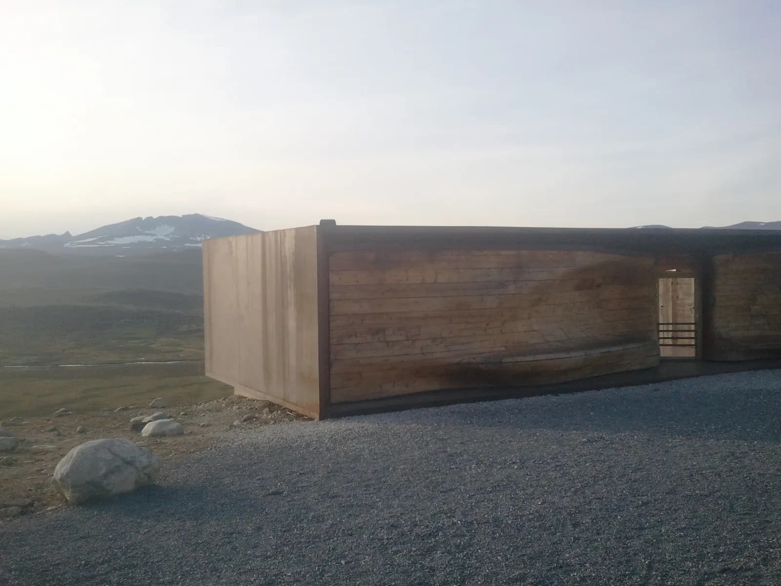
Turn off the E6 at Hjerkinn towards Snøheim and drive around two kilometres west on gravel to the car park at Tverrfjellet. Walk the final stretch: around 1.5 kilometres on a gravel path, gaining around 120 metres. Norsk Villreinsenter commissioned the Snøhetta architects to design the pavilion, completed in 2011. Its glass wall faces Snøhetta, 2,286 metres — Norway has no higher mountain outside Jotunheimen. Below lies the former firing range, now mostly national park. If you see musk oxen, the same rule applies: 200 metres.
Don't miss: The remains of the mines on Tverrfjellet by the car park. Folldal Verk extracted ore here from 1964 to 1993.
Motorhome tip: Drive slowly on the gravel road and turn towards the car park before the barrier on the road to Snøheim. Private cars cannot pass the barrier.
5. Lesja — the church and the village museum
Back in Dombås, take the E136 west, upstream beside Gudbrandsdalslågen. After around 15 kilometres you reach Lesja. Little rain falls here — the western mountains take most of it. Before irrigation systems arrived, farmers erected snow fences in their fields to retain moisture.
Don't miss: The timber church from 1749, with an altarpiece carved by Jakob Klukstad. Nearby is the open-air museum Lesja bygdetun.
Motorhome tip: Aurstad handel, east of the centre, has an automated fuel pump. Lora rest area, between Lesja and Lesjaverk, has six spaces for large vehicles and toilets open all year.
6. Lesjaverk and Lesjaskogsvatnet — the lake that flows both ways
Lesjaskogsvatnet begins at Lesjaverk. The ironworks dammed two lakes into one in the 1660s; since then the lake has had outlets at both ends: Rauma westwards, Lågen eastwards. The works closed in 1812, but the owner's house still stands, protected.
Between Lesja and Bjorli the E136 passes close to or through farmyards in several places. Signs warn you — slow down.
Don't miss: The log church at Lesjaskog, from 1697.
Motorhome tip: Lesjaskogsvatnet Camping lies by the E136 beside the lake and rents out boats and canoes.
7. Bjorli and Kylling bru — down into Romsdalen
Bjorli, 574 metres above sea level, is the last stop in Innlandet. The tourist train from Åndalsnes turns here. Then the descent begins: from the county boundary at Stuguflåten to the bottom of Romsdalen, the E136 drops around 360 metres in just over eleven kilometres.
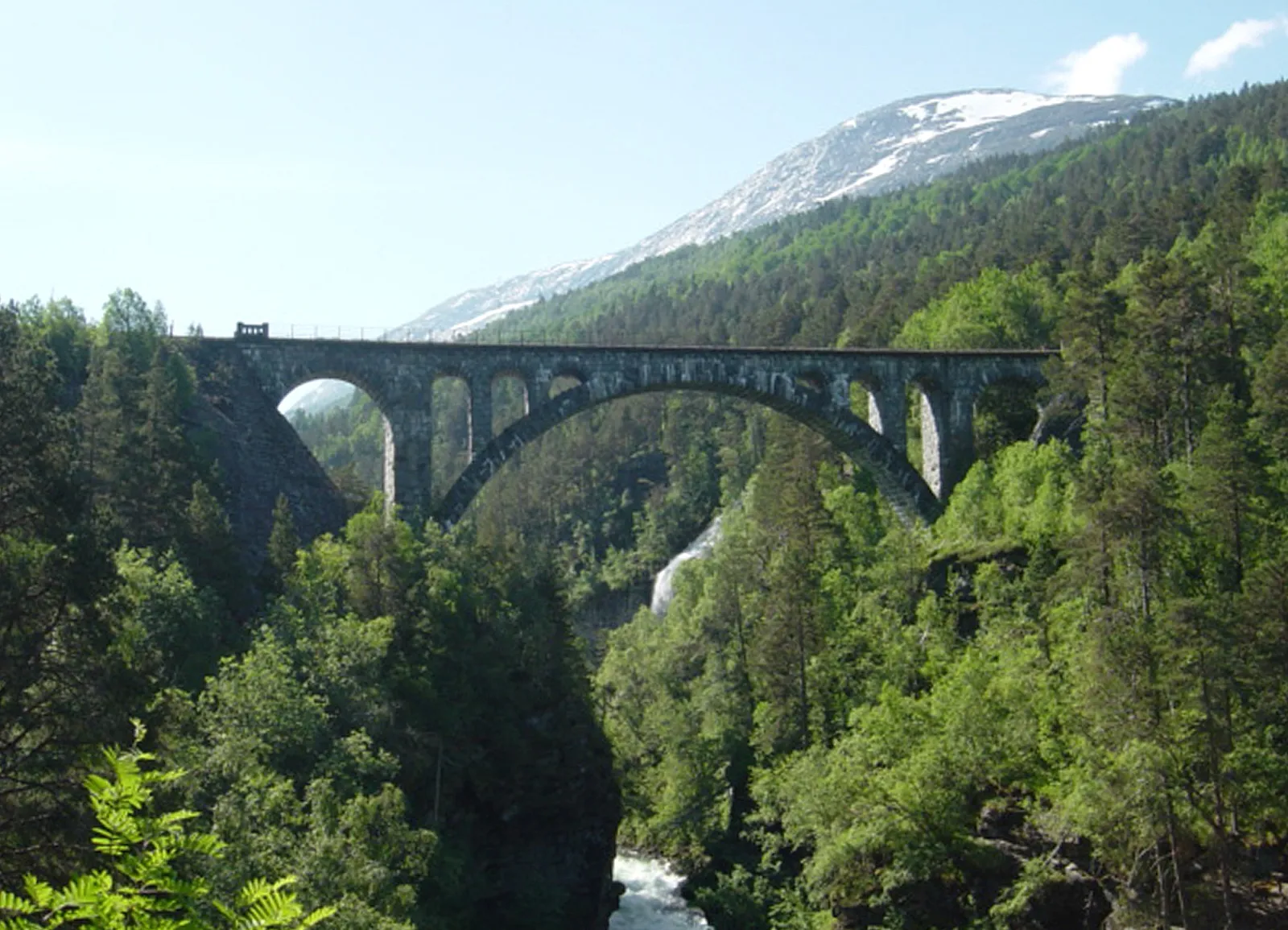
At Verma, Raumabanen crosses the Rauma on Kylling bru, a stone bridge from 1923, around 60 metres above the river. Nearby, the railway winds through two reversing tunnels in the mountain.
Motorhome tip: Signs from the E136 lead to parking at Kyllingbrua, with two viewpoints nearby. The rest area at Slettafossen, just before it, has two spaces for large vehicles but closes from mid-September to mid-May.
8. Mannen, Trollveggen and Romsdalshornet
The valley walls grow taller downstream. At Horgheim you pass beneath Mannen, a mountainside monitored around the clock because it may collapse. In 2019 a section, Veslemannen, fell.
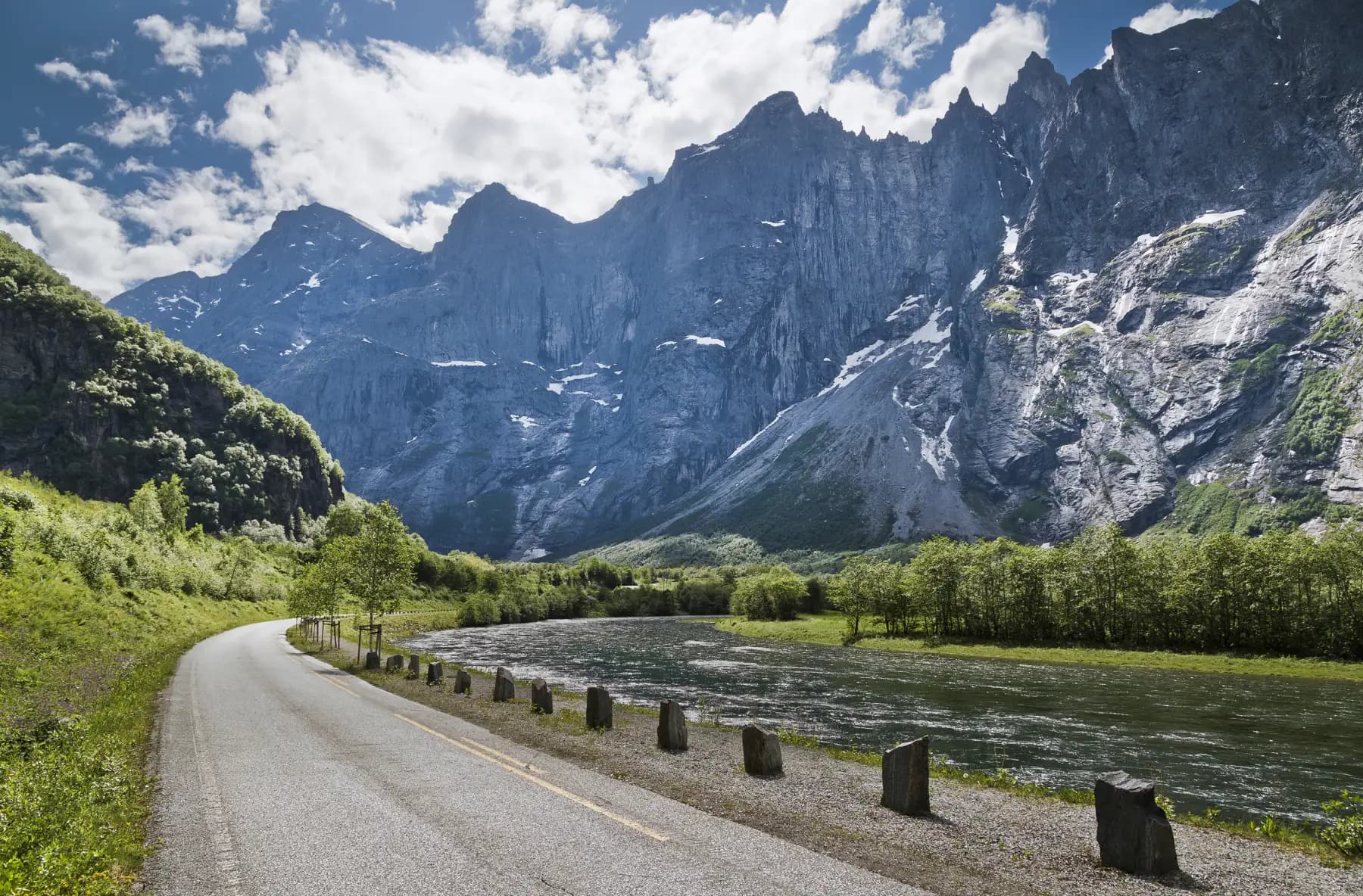
A little further down, Trollveggen drops around 1,000 metres vertically. Nobody climbed the face itself until 1965, when the ascent took almost two weeks. Opposite stands Romsdalshornet, 1,550 metres, climbed as early as 1828.
Don't miss: The visitor centre at the rest area, designed by Reiulf Ramstad Arkitekter and opened in 2012.
Motorhome tip: The rest area beneath Trollveggen is built for vehicle combinations, has drinking water and is open all year. Trollveggen Camping lies just under a kilometre north of it.
9. Åndalsnes — the gondola and Rampestreken
Romsdalsgondolen takes you from the fjord to Nesaksla, 708 metres above sea level, in seven minutes, all year. From the upper station, walk downhill for around a quarter of an hour to Rampestreken, a narrow platform projecting over the edge. On foot, Romsdalstrappa from the centre takes around an hour and a half.
Motorhome tip: The municipal motorhome car park at Victoriaplassen cannot be booked. It has water but no waste disposal — the municipality refers you to Esso Øran. In winter the site is smaller and not cleared of snow.
Practical info for motorhomes
Roads: The E6 and E136 are open to vehicle combinations of 19.5 metres throughout (Statens vegvesen's road database), with no signed height limit. The lowest point is a railway underpass at Foss in Romsdalen, with 4.3 metres of clearance. There are two short tunnels: Fantebrauta at Horgheim (240 metres) and Halsatunnelen at Sogge bru (140 metres). For uphill drivers, signs warn of a 6 % gradient over twelve kilometres. Downhill: low gear and engine braking.
Winter: Both roads are open all year, but bad weather may bring convoy driving or closures on the E6 over Dovrefjell, with a barrier just north of Dombås. Romsdalen is prone to avalanches and rockfalls: in March 2010 the E136 between Brude and Sogge bru closed repeatedly for avalanches over four days. Check vegvesen.no/trafikk or call 175.
Parking: Fokstua nord, Lora and Trollveggen rest areas take large vehicles all year; Slettafossen and Bjorli vest close for winter. In Åndalsnes: the motorhome car park at Victoriaplassen.
Overnight stays: The Outdoor Recreation Act allows tents on uncultivated land at least 150 metres from an inhabited house or cabin, for at most two nights without the landowner's consent (the time limit does not apply in high mountains). It gives no right to park a motorhome — signs and landowner rules apply. Never drive off-road into the terrain. Use campsites.
Campsites:
- Faksfall Camping — around four kilometres south of Dombås
- Lesjaskogsvatnet Camping — beside the E136 and the lake at Lesjaskog
- Trollveggen Camping — in Romsdalen, ten kilometres south of Åndalsnes, open 9 May–20 September, with a dump station
- Åndalsnes Camping og Motell — beside the Rauma in Åndalsnes; late in the season motorhome pitches are allocated on arrival
- Bobilparkering Åndalsnes — Victoriaplassen, cannot be booked, water, no waste disposal
Fuel: Dombås, with a 24-hour Circle K. No fuel station between Dombås and Hjerkinn. Along the E136: an automated pump east of Lesja, YX at Bjorli, a station at Verma and several in Åndalsnes.
Waste disposal: Rauma municipality refers you to Esso Øran in Åndalsnes. Åndalsnes Camping and Trollveggen Camping have their own dump stations. On the mountain side, Nasjonale turistveger lists Hjerkinn among the nearest disposal locations without specifying where. The safest option is to empty in Åndalsnes or at a campsite.
Ferries: No ferries.
Combine with
- Trollstigen and Geiranger — starts in Åndalsnes. Fv 63 branches off at Sogge bru, five kilometres up the valley.
- Rondane and Peer Gynt-vegen — from Hjerkinn it is around 30 kilometres on Fv 29 to Folldal, where that route ends. Follow it south in reverse.
- Moskusstien — a marked trail in the national park, with loops of 4.5 to 15 kilometres from Kongsvoll or Grønbakken, north of Hjerkinn.
Weather
Around Lesja it is dry, with mild summers and cold winters. On Dovrefjell, around a thousand metres above sea level, it is colder and windier. Towards the fjord, more rain falls. Check yr.no for Dombås, Hjerkinn and Åndalsnes, and “E6 Dovrefjell” under mountain passes.
This route is part of Bobilvei's hand-picked motorhome routes in Norway. Every route is quality-checked with a focus on motorhome suitability, parking and local experiences.